Index of /public/incident_specific_data/calif_s/2020_Incidents/CA-LPF-002428_Dolan/GIS/Products/20200905
Name
Last modified
Size
Description
Parent Directory
-
transportation_arch_c_land_20200904_2225_Dolan_002428_0905.pdf
2020-09-05 02:11
2.7M
fban_archE_port_20200905_1330_Dolan_LPF0024258.pdf
2020-09-05 18:03
13M
evacuation_36x48_port_20200904_2206_Dolan_LPF002428_0905day_opt.pdf
2020-09-05 00:19
7.1M
airops_arch_e_land_20200904_2130_Dolan_CALPF002428_0905day_Linked.pdf
2020-09-05 08:53
4.3M
airops_arch_e_land_20200904_2130_Dolan_CALPF002428_0905day.pdf
2020-09-05 01:06
6.5M
PilotMap_withTable_11x17_Land_20200904_2355_Dolan_LPF002428_0905_Linked.pdf
2020-09-05 09:57
1.3M
PilotMap_withTable_11x17_Land_20200904_2355_Dolan_LPF002428_0905.pdf
2020-09-05 02:24
1.0M
PilotMap_11x17_Land_20200904_2323_Dolan_LPF002428_0905.pdf
2020-09-05 02:24
1.0M
PIO_ArchE_port_20200904_2204_Dolan_LPF002428_0905day_opt.pdf
2020-09-05 00:19
4.2M
PIO_11X17_port_20200904_2204_Dolan_LPF002428_0905day_opt.pdf
2020-09-05 00:19
457K
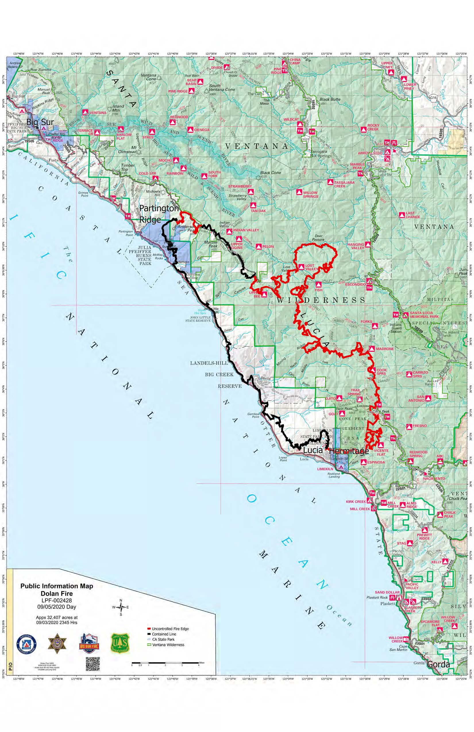
PIO_11X17_port_20200904_2204_Dolan_LPF002428_0905day_opt.jpg
2020-09-05 00:19
448K
Ops_archE_port_20200904_2242_Dolan_LPF0024258_0905_opt.pdf
2020-09-05 02:30
15M
Ops_archE_port_20200904_2242_Dolan_LPF0024258_0905.pdf
2020-09-05 02:10
16M
OpsBranchV_archE_port_20200904_2242_Dolan_LPF0024258_0905.pdf
2020-09-05 02:11
9.3M
OpsBranchV_archE_land_20200904_2335_Dolan_LPF0024258.pdf
2020-09-05 02:09
10M
IAP/
2020-09-05 09:53
-
AirTable_11x17_Port_20200904_2355_Dolan_002428_0905.pdf
2020-09-05 02:23
9.9K