Index of /public/incident_specific_data/southwest/GACC_Incidents/2022/2022_Black/GIS/Products/20220615/Morning
Name
Last modified
Size
Description
Parent Directory
-
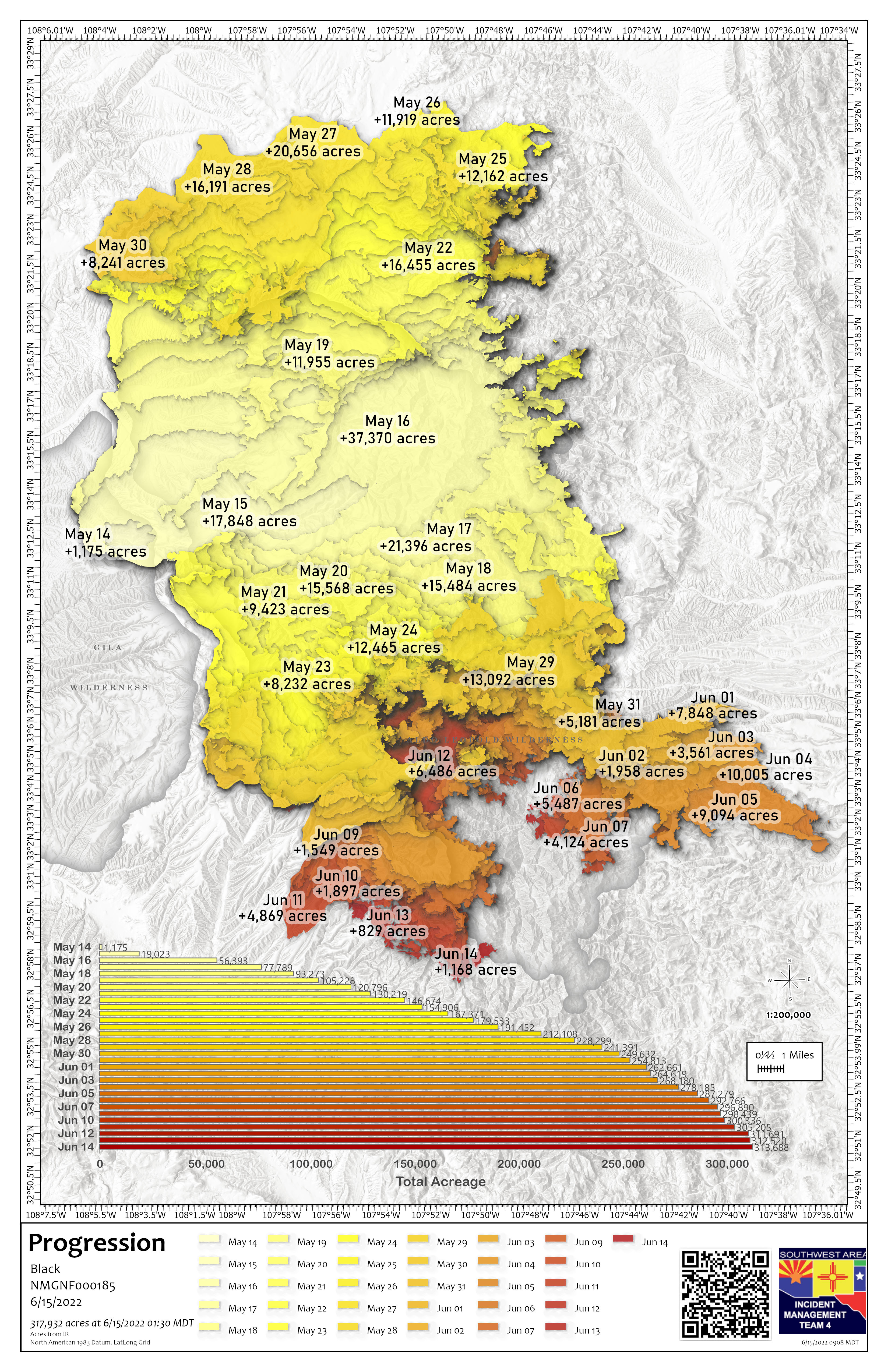
progression_11x17_port_20220615_0905_Black_NMGNF000185_0615day.jpg
2022-06-15 10:10
3.0M
progression_11x17_port_20220615_0902_Black_NMGNF000185_0615day.pdf
2022-06-15 10:08
715K
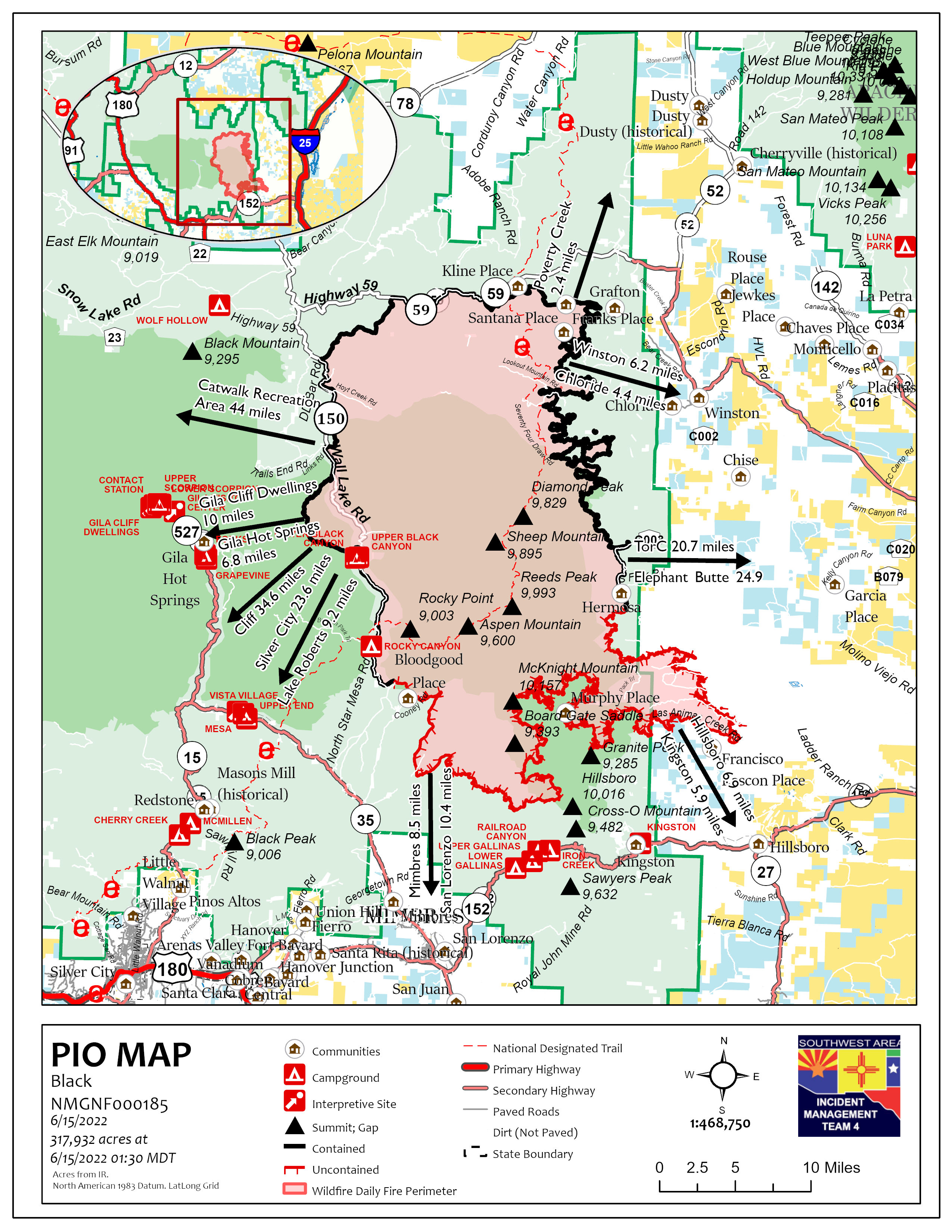
pio_85x11_port_20220615_0800_Black_NMGNF000185_0615.jpg
2022-06-15 09:03
1.6M
PIO_36x48_ArchE_Port_20220615_0742_Black_NMGNF000185_0615.pdf
2022-06-15 08:54
11M
pio_85x11_port_20220615_0733_Black_NMGNF000185_0615.pdf
2022-06-15 08:53
1.0M
SuppRepairTable_11x17_Land_20220615_0617_Black_NMGNF000185_0615day.pdf
2022-06-15 07:21
401K
SuppRepairNorth_36x48_ArchE_Land_20220615_0557_Black_NMGNF000185_0615day.pdf
2022-06-15 07:07
10M
SuppRepairSouth_36x48_ArchE_Land_20220615_0531_Black_NMGNF000185_0615day.pdf
2022-06-15 06:57
15M
PilotTable_11x17_port_20220615_0421_Black_NMGNF000185_0615day.pdf
2022-06-15 05:25
365K
PilotMapTable_COMBINED_11x17_port_20220615_0423_Black_NMGNF000185_0615day.pdf
2022-06-15 05:25
1.2M
PilotMap_11x17_port_20220615_0415_Black_NMGNF000185_0615day.pdf
2022-06-15 05:25
857K
AirOps_arch_e_port_20220615_0404_Black_NMGNF000185_0615day.pdf
2022-06-15 05:16
11M
Ops_DivR_e_land_20220615_0358_Black_NMGNF000185_0615day.pdf
2022-06-15 05:06
8.2M
StratPlan_36x48_ArchE_Port_20220615_0339_Black_NMGNF000185_0615day.pdf
2022-06-15 05:00
16M
Ops_IR_NORTH_e_land_20220615_0351_Black_NMGNF000185_0615day.pdf
2022-06-15 05:00
12M
Ops_IR_SOUTH_e_land_20220615_0344_Black_NMGNF000185_0615day.pdf
2022-06-15 04:53
12M
MedTrans_arch_e_land_20220615_0337_Black_NMGNF000185_0615day.pdf
2022-06-15 04:41
6.3M
Briefing_ArchE_port_20220615_0333_Black_NMGNF000185_0615day.pdf
2022-06-15 04:40
6.8M