Index of /public/incident_specific_data/calif_n/2015 FEDERAL_Incidents/CA-SRF-001433_Mad_River_Complex/GIS/products/20150825
Name
Last modified
Size
Description
Parent Directory
-
iap_index_11x17_port_20150825_0600_MadRiverComplex_CASRF1433.pdf
2015-08-25 00:24
15M
iap_index_11x17_port_20150826_0600_MadRiverComplex_CASRF1433.pdf
2015-08-25 23:57
11M
iapdd_11x17_port_20150825_0600_MadRiverComplex_CASRF1433.pdf
2015-08-25 00:23
22M
iapdd_11x17_port_20150826_0600_MadRiverComplex_CASRF1433.pdf
2015-08-25 23:57
11M
ops_PickGobbler_ansi_e_land_20150826_0600_Mad RiverComplex_CASRF1433.pdf
2015-08-26 00:04
10M
ops_ansi_e_land_20150826_0600_Mad RiverComplex_CASRF1433.pdf
2015-08-26 00:06
10M
ops_ir_PickGobbler_ansi_e_land_2015_0521_Mad RiverComplex_CASRF1433.pdf
2015-08-25 08:22
11M
ops_ir_ansi_e_port_20150825_0521_Mad RiverComplex_CASRF1433.pdf
2015-08-25 08:20
8.2M
ops_ir_lassic_ansi_e_port_2015_0525_Mad RiverComplex_CASRF1433.pdf
2015-08-25 08:22
9.5M
ops_lassic_ansi_e_port_20150826_0600_Mad RiverComplex_CASRF1433.pdf
2015-08-26 00:07
9.3M
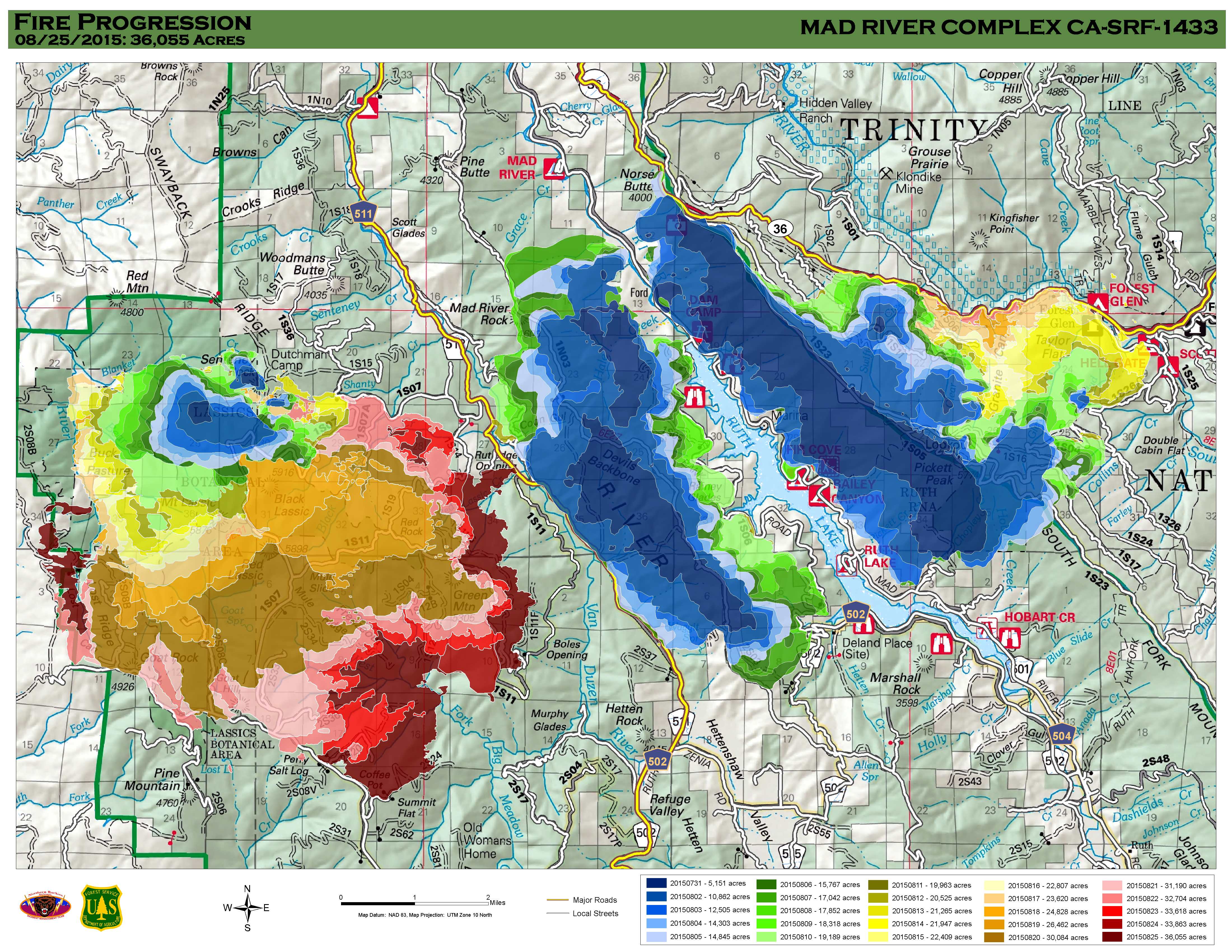
progression_ansi_e_land_2015_MadRiverComplex_SRF_1433.jpg
2015-08-25 14:12
1.8M
trans_11x17_port_2015_MadRiverComplex_CASRF1433.pdf
2015-08-25 00:22
14M
trans_11x17_port_20150826_0600_MadRiverComplex_CASRF1433.pdf
2015-08-26 00:05
14M