Index of /public/incident_specific_data/calif_s/2020_Incidents/CA-LPF-002428_Dolan/GIS/Products/20200907
Name
Last modified
Size
Description
Parent Directory
-
IAP/
2020-09-07 00:05
-
OpsBranchV_archE_land_20200907_0008_Dolan_LPF0024258_0907.pdf
2020-09-07 03:18
12M
Ops_archE_port_20200906_0106_Dolan_LPF0024258.pdf
2020-09-07 03:22
17M
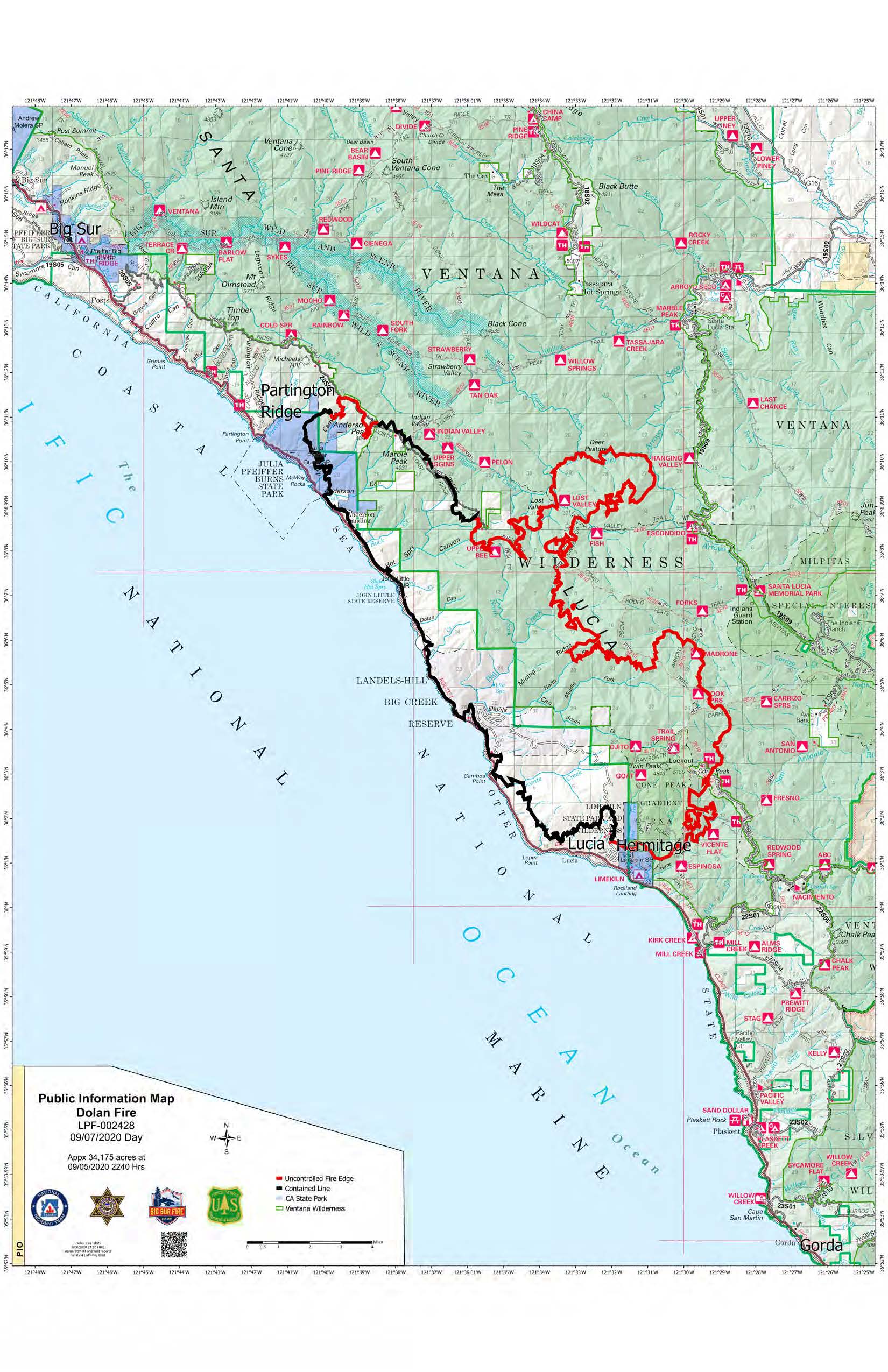
PIO_11x17_port_20200906_2119_Dolan_LPF002428_0907day_opt.jpg
2020-09-06 23:36
448K
PIO_11x17_port_20200906_2119_Dolan_LPF002428_0907day_opt.pdf
2020-09-06 23:36
458K
PIO_ArchE_port_20200906_2127_Dolan_LPF002428_0907day_opt.pdf
2020-09-06 23:37
3.7M
airops_arch_e_land_20200906_2113_Dolan_CALPF002428_0907day.pdf
2020-09-06 23:42
6.8M
airops_arch_e_land_20200906_2113_Dolan_CALPF002428_0907day_Linked.pdf
2020-09-07 08:19
4.1M
evacuation_11x17_port_20200907_1830_Dolan_LPF002428_0908day_zone14.pdf
2020-09-07 21:33
1.8M
evacuation_11x17_port_20200907_1830_Dolan_LPF002428_0908day_zone24.pdf
2020-09-07 21:34
1.7M
evacuation_11x17_port_20200907_1830_Dolan_LPF002428_0908day_zone26.pdf
2020-09-07 21:33
1.5M
evacuation_36x48_port_20200907_1928_Dolan_LPF002428_0908day.pdf
2020-09-07 21:35
7.4M
iap_index_11x17_land_20200906_2200_Dolan_CALPF002428_0907_Linked.pdf
2020-09-07 08:11
705K
pilot_11x17_land_20200907_2100_Dolan_CALPF002428_0907.pdf
2020-09-06 23:23
2.0M
pilot_11x17_land_20200907_2100_Dolan_CALPF002428_0907_Linked.pdf
2020-09-07 08:14
2.0M
pilot_airtable_11x17_land_20200907_2100_Dolan_CALPF002428_0907.pdf
2020-09-06 23:23
2.1M
transportation_arch_c_land_20200906_2222_Dolan_002428_0907.pdf
2020-09-07 01:32
3.5M