Index of /public/incident_specific_data/calif_s/2020_Incidents/CA-LPF-002428_Dolan/GIS/Products/20200916
Name
Last modified
Size
Description
Parent Directory
-
ArroyoSecoStructures_ArchE_land_20200915_2130_Dolan_LPF002428_0916day.pdf
2020-09-16 01:20
2.1M
IAP/
2020-09-16 01:03
-
OpsDIVP_archE_port_20200915_2257_Dolan_LPF0024258_0916.pdf
2020-09-16 01:05
8.7M
Ops_archE_port_20200915_2231_Dolan_LPF0024258_0916.pdf
2020-09-16 00:53
41M
Progression_ArchE_land_20200915_1600_Dolan_LPF002428_0916day.pdf
2020-09-16 01:34
5.3M
Transportation_MapSeries_Layout_ArchC_Land.pdf
2020-09-16 00:02
4.3M
WeatherMatrix_Dolan_091520_nc.pdf
2020-09-16 00:01
297K
airops_archE_land_20200915_2200_Dolan_CALPF002428_16day.pdf
2020-09-16 01:05
4.8M
airtable_11x17_port_20200915_2200_Dolan_CALPF002428_16day.pdf
2020-09-16 01:05
89K
evacuation_11x17_port_20200915_2245_Dolan_LPF002428_0916day_mapseries.pdf
2020-09-16 01:20
11M
evacuation_OPS_ArchE_land_20200915_2130_Dolan_LPF002428_0916day.pdf
2020-09-16 01:21
7.1M
evacuation_PIO_ArchE_land_20200915_2330_Dolan_LPF002428_0916day.pdf
2020-09-16 01:39
4.7M
pilot_11x17_land_20200915_2200_Dolan_CALPF002428_16day.pdf
2020-09-16 01:04
1.9M
pilotairtable_11x17_land_20200915_2200_Dolan_CALPF002428_16day.pdf
2020-09-16 01:04
2.0M
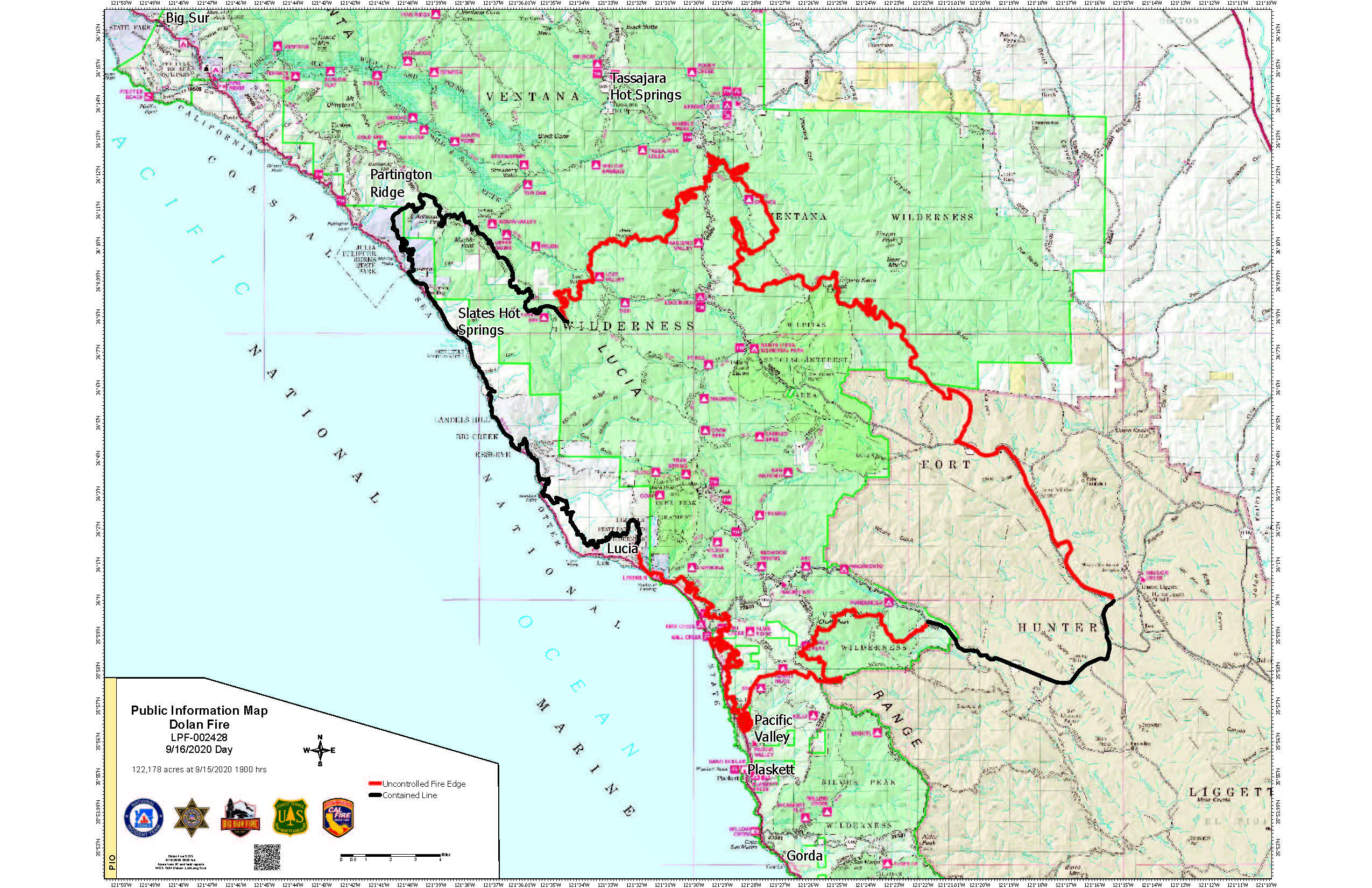
pio_11x17_land_20200915_2330_Dolan_CALPF002428_0916day.jpg
2020-09-16 01:34
965K
pio_11x17_land_20200915_2330_Dolan_CALPF002428_0916day.pdf
2020-09-16 01:34
3.1M
pio_ArchE_land_20200915_2330_Dolan_CALPF002428_0916day.pdf
2020-09-16 01:30
2.3M