Index of /public/incident_specific_data/calif_s/2020_Incidents/CA-LPF-002428_Dolan/GIS/Products/20200918
Name
Last modified
Size
Description
Parent Directory
-
20200918_0800_Dolan_perimeter.kmz
2020-09-18 10:34
68K
AirTable_11x17_port_20200917_2100_Dolan_CALPF002428_0918.pdf
2020-09-18 00:54
57K
ArroyoSecoStructures_ArchE_land_20200917_2030_Dolan_LPF002428_0918day.pdf
2020-09-17 23:08
2.3M
IAP/
2020-09-17 23:41
-
Ops_archE_port_20200917_2254_Dolan_LPF0024258_2018.pdf
2020-09-18 01:07
40M
Progression_ArchE_land_20200917_2130_Dolan_LPF002428_0918day.pdf
2020-09-17 23:46
3.6M
WeatherMatrix_Dolan_091720.pdf
2020-09-18 00:56
296K
airops_archE_land_20200917_2100_Dolan_CALPF002428_0918.pdf
2020-09-17 23:41
3.9M
evacuation_11x17_port_20200918_0800_Dolan_LPF002428_0918day_mapseries.pdf
2020-09-18 10:18
11M
evacuation_11x17_port_20200918_1200_Dolan_LPF002428_0918day_mapseries.pdf
2020-09-18 15:30
11M
evacuation_OPS_ArchE_land_20200918_0800_Dolan_LPF002428_0918day.pdf
2020-09-18 10:14
7.3M
evacuation_OPS_ArchE_land_20200918_1200_Dolan_LPF002428_0918day.pdf
2020-09-18 14:36
6.9M
evacuation_PIO_ArchE_land_20200918_0800_Dolan_LPF002428_0918day.pdf
2020-09-18 10:08
4.9M
evacuation_PIO_ArchE_land_20200918_1200_Dolan_LPF002428_0918day.pdf
2020-09-18 14:40
4.8M
pilot_11x17_land_20200917_2100_Dolan_CALPF002428_0918.pdf
2020-09-18 01:16
1.6M
pilot_wTable_11x17_land_20200917_2100_Dolan_CALPF002428_0918.pdf
2020-09-18 01:16
1.6M
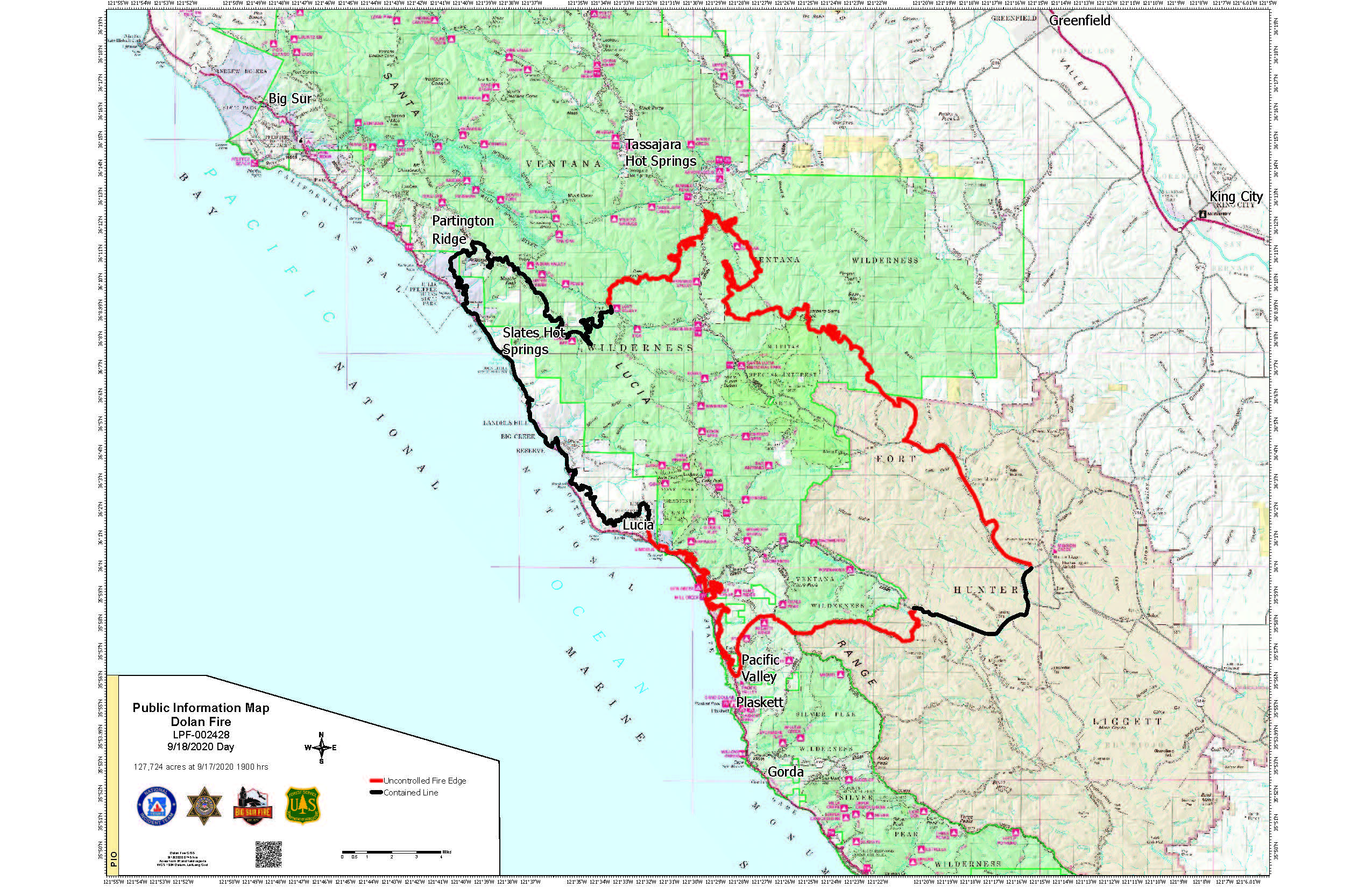
pio_11x17_land_20200918_0745_Dolan_CALPF002428_0918day.jpg
2020-09-18 09:46
910K
pio_11x17_land_20200918_0745_Dolan_CALPF002428_0918day.pdf
2020-09-18 09:46
3.0M
pio_ArchE_land_20200918_0745_Dolan_CALPF002428_0918day.pdf
2020-09-18 09:47
2.1M
transportation_arch_c_land_20200918_0820_Dolan_002428_0918.pdf
2020-09-18 10:22
4.4M