| Name | Last modified | Size | Description | |
|---|---|---|---|---|
| Parent Directory | - | |||
| 2015_AirOps100MileRadius_opt.pdf | 2015-09-03 02:31 | 8.1M | ||
| 2015_Tepee_AirOps_TFR_Sectional.pdf | 2015-09-03 08:15 | 9.7M | ||
| 2015_Tepee_AirOps_TFR_Sectional_Current.pdf | 2015-09-03 08:15 | 9.7M | ||
| 2015_Tepee_Dispatch_ANSIE_P.pdf | 2015-09-03 08:17 | 13M | ||
| 2015_Tepee_PIO_11x17_P.pdf | 2015-09-03 08:16 | 1.9M | ||
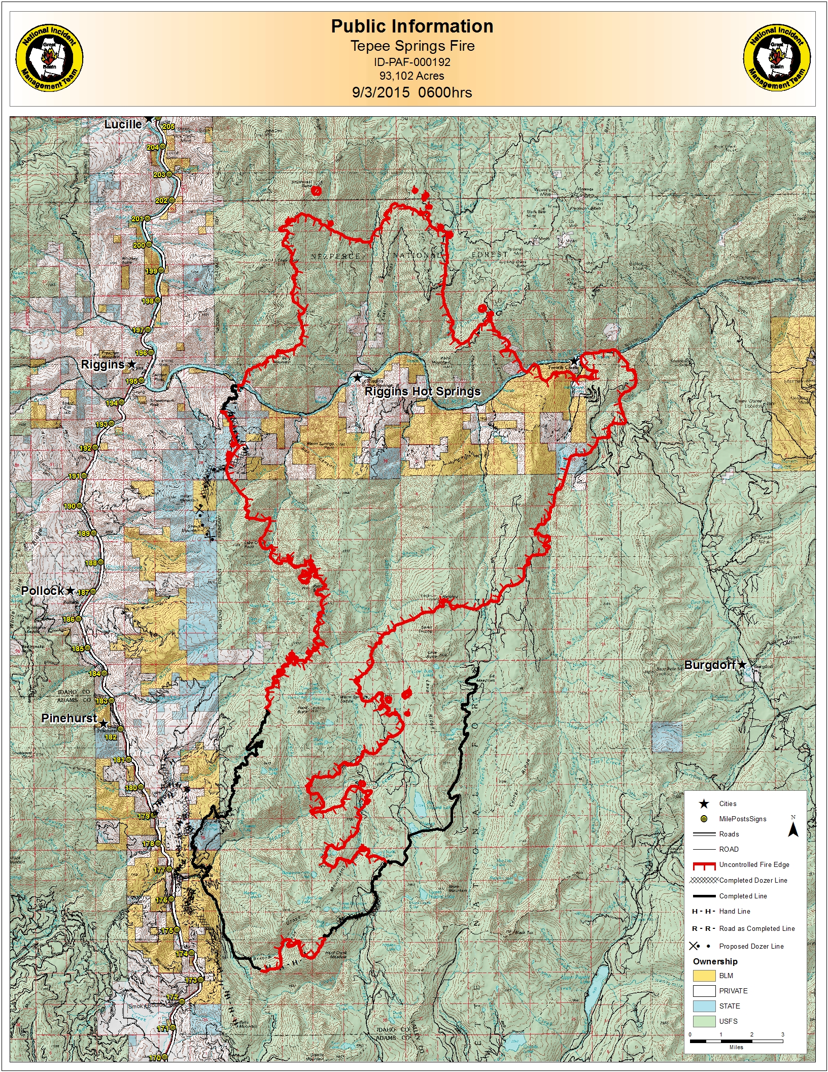
| 2015_Tepee_PIO_ANSIC_P_Topo.jpg | 2015-09-03 12:24 | 4.8M | ||
| 2015_Tepee_PIO_ANSIE_P.pdf | 2015-09-03 08:18 | 9.1M | ||
| 20150903_0000_Tepee_AirOperations_Ez2.pdf | 2015-09-03 02:34 | 12M | ||
| 20150903_0000_Tepee_AirOperations_Pilot_Map_11x17.pdf | 2015-09-03 02:34 | 2.2M | ||
| 20150903_0000_Tepee_AirOperations_Pilot_Table_11x17.pdf | 2015-09-03 02:34 | 64K | ||
| 20150903_0000_Tepee_BAM.pdf | 2015-09-03 02:34 | 6.4M | ||
| 20150903_0000_Tepee_Operations_E_FSTopo.pdf | 2015-09-03 02:36 | 18M | ||
| 20150903_0000_Tepee_Planning_E.pdf | 2015-09-03 02:37 | 21M | ||
| 20150903_0000_Tepee_Transpo_ANSIE_P.pdf | 2015-09-03 02:38 | 13M | ||
| 20150903_0615_Tepee_AirOperations_Pilot_MapWithTable_11x17.pdf | 2015-09-03 08:12 | 922K | ||