Index of /public/incident_specific_data/n_rockies/Historic_archived NIROPS/2017_fires/2017_Liberty/GIS/Products/20170818
Name
Last modified
Size
Description
Parent Directory
-
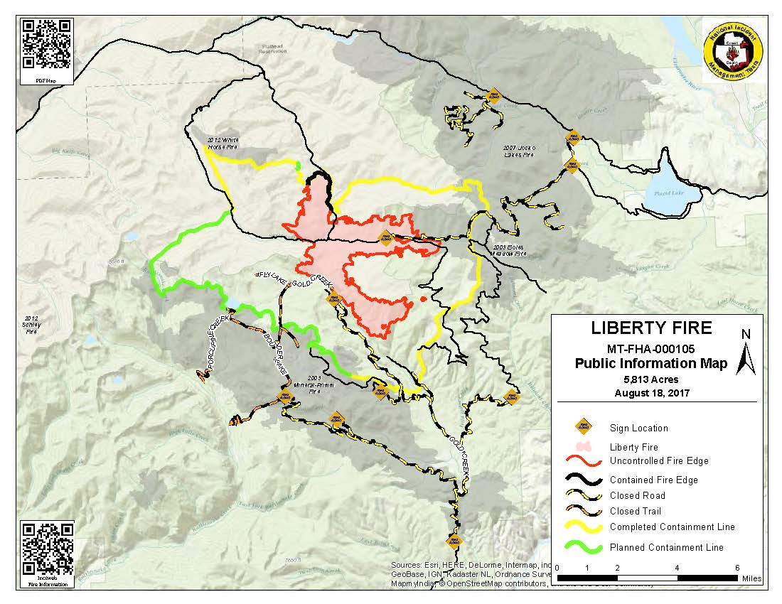
PIO_8x11_land_20170818_0655_Liberty_MTFHA105.jpg
2017-08-18 07:56
147K
PIO_8x11_land_20170818_0655_Liberty_MTFHA105.pdf
2017-08-18 07:56
271K
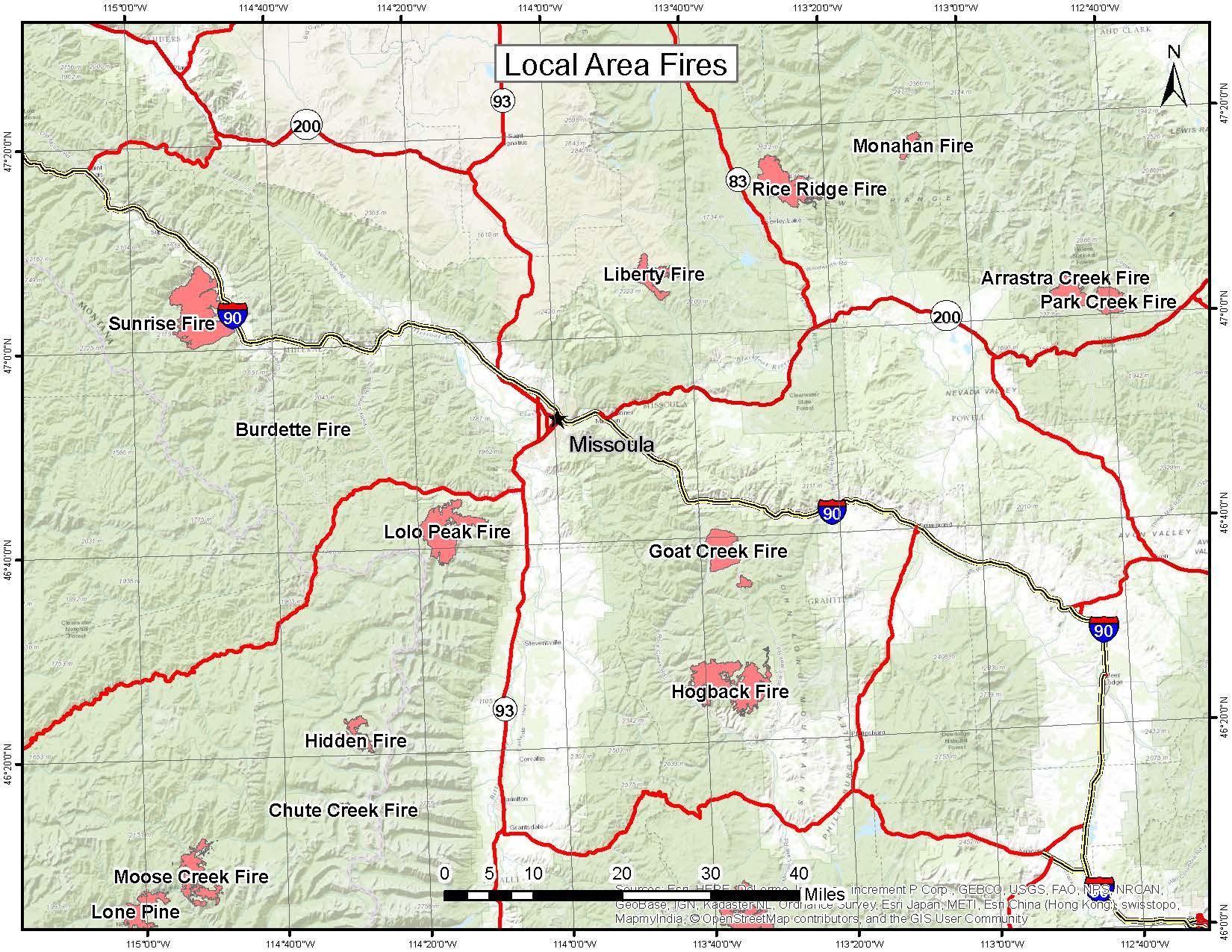
AreaFires_8x11_land_20170818_1140_Liberty_MTFHA105.jpg
2017-08-18 16:23
322K
AirOps_11x17_land_20170817_2145_Liberty_MTFHA105.pdf
2017-08-17 22:43
368K
Trans_85X11_land_20170817_1650_Liberty_MTFHA105.pdf
2017-08-17 22:43
487K
PIO_8x11_land_20170817_2115_Liberty_MTFHA105.pdf
2017-08-17 22:42
567K
20170818_IR_Liberty_11X17_TOPO.pdf
2017-08-18 06:53
823K
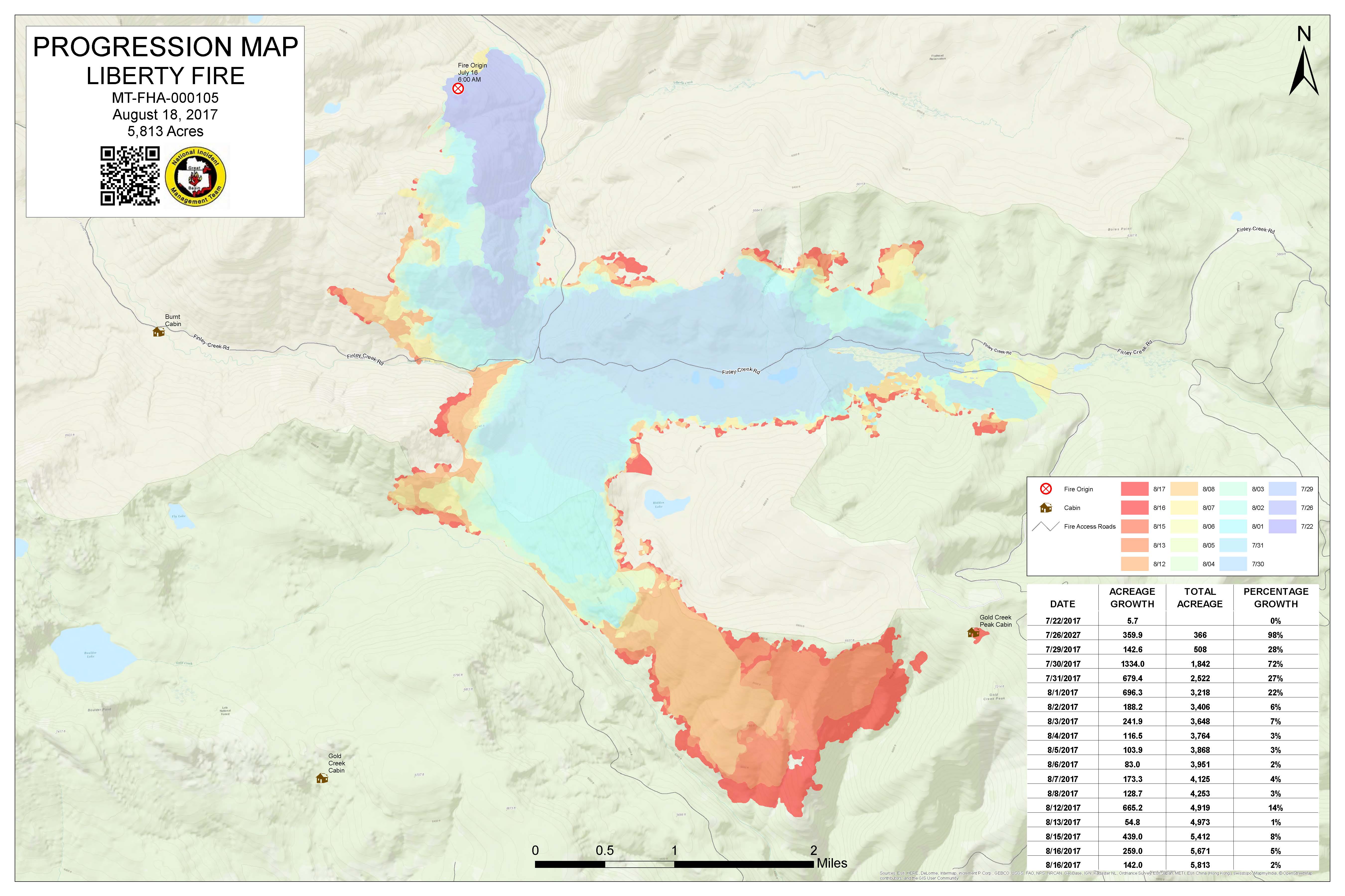
Progression_archD_land_20170818_740_MTFHA105_FTP.jpg
2017-08-18 08:43
888K
AreaFires_8x11_land_20170818_1140_Liberty_MTFHA105.pdf
2017-08-18 16:23
892K
Progression_archD_land_20170818_740_MTFHA105_FTP.pdf
2017-08-18 08:43
1.1M
IAP_85x11_land_20170817_1640_Liberty_MTFHA105.pdf
2017-08-17 22:40
1.2M
Trans_ArchD_land_20170817_1700_Liberty_MTFHA105.pdf
2017-08-17 22:43
1.4M
OPS_ArchC_land_20170817_2115_Liberty_MTFHA105.pdf
2017-08-17 22:42
2.6M
OPS_ArchE_land_20170817_2043_Liberty_MTFHA105.pdf
2017-08-17 22:43
2.9M
Repair_ArchE_land_20170817_2120_Liberty_MTFHA105.pdf
2017-08-17 22:43
3.3M
DivT_ArchC_land_20170817_1755_Liberty_MTFHA105.pdf
2017-08-17 22:41
3.6M
DivCM_ArchC_land_20170817_1755_Liberty_MTFHA105.pdf
2017-08-17 22:40
3.7M
IAP_ArchD_land_20170817_1650_Liberty_MTFHA105.pdf
2017-08-17 22:42
3.7M
DivAB_ArchC_land_20170817_1755_Liberty_MTFHA105.pdf
2017-08-17 22:40
3.9M
WFDSS_ArchE_land_20170817_Liberty_MTFHA105.pdf
2017-08-17 22:44
4.5M