Index of /public/incident_specific_data/pacific_nw/Z_2020_HISTORIC/2020_Incidents_Oregon/2020_ArchieCreek_ORUPF_000436/GIS/PRODUCTS/20200922
Name
Last modified
Size
Description
Parent Directory
-
pilot_wIR_11x17_land_20200922_0622_Archie Creek_ORUPF000436_0922day_opt.pdf
2020-09-22 08:33
2.7M
ops_wIR_arch_e_land_20200922_0601_Archie Creek_ORUPF000436_0922day_opt.pdf
2020-09-22 08:27
12M
transportation_arch_e_land_20200921_1917_ArchieCreek_ORUPF000436_0922Day_ArcMap_10_7_opt.pdf
2020-09-21 22:36
9.9M
transportation_11x17_land_20200921_1917_ArchieCreek_ORUPF000436_0922Day_ArcMap_10_7_opt.pdf
2020-09-21 22:36
5.1M
PlanningOps_arch_e_land_20200921_2009_ArchieCreek_ORUPF000436_0922Day_ArcMap_10_7_opt.pdf
2020-09-21 22:35
12M
pio_11x17_land_20200921_1930_Archie Creek_OR-UPF00436_ArcMap_0922dayt.pdf
2020-09-21 22:35
3.6M
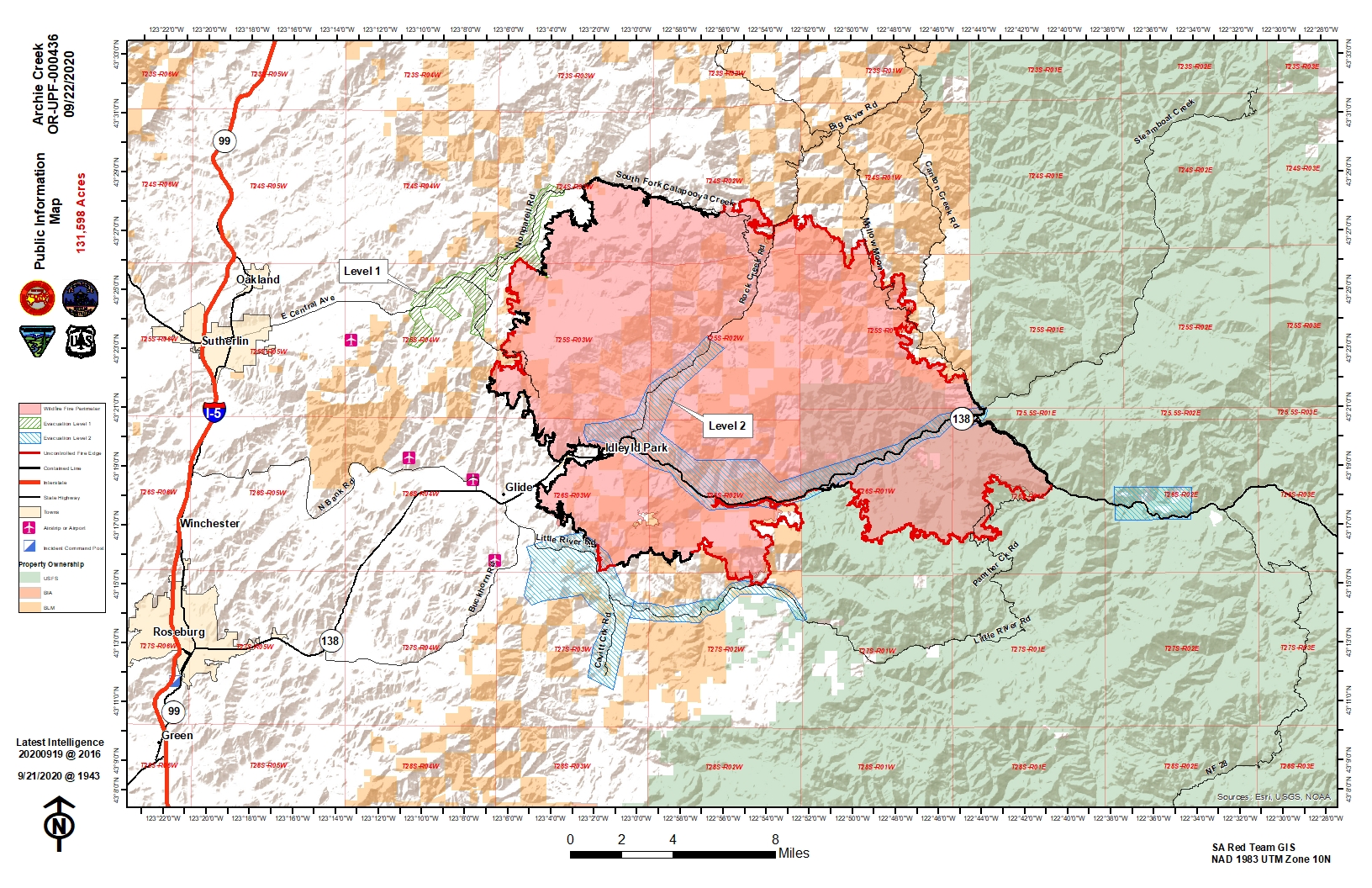
pio_11x17_land_20200921_1930_Archie Creek_OR-UPF00436_ArcMap_0922day.jpg
2020-09-21 22:35
1.5M
pilot_table_11x17_land_20200921_1945_Archie Creek_ORUPF000436_0922day_opt.pdf
2020-09-21 22:35
67K
pilot_11x17_land_20200921_1910_Archie Creek_ORUPF000436_0922day_opt.pdf
2020-09-21 22:35
2.7M
ops_arch_e_land_20200921_1912_ArchieCreek_ORUPF000436_0922Day_ArcMap_10_7_opt.pdf
2020-09-21 22:35
14M
IAP_Trans Mapbook_11x17_L_20200921_201920_ArchieCreek_ORUPF000436_0922Day.pdf
2020-09-21 22:34
23M
brief_arch_e_land_20200921_2025_Archie Creek_OR-UPF00436_0922DAY.pdf
2020-09-21 22:33
4.1M
BranchIOps_arch_e_land_20200921_2000_Archie Creek_ORUPF000436_ArcMap_0922day7.pdf
2020-09-21 22:33
3.4M
BranchIIOps_arch_e_land_20200921_2000_Archie Creek_ORUPF000436_ArcMap_0922day.pdf
2020-09-21 22:33
5.5M
BranchIIIOps_arch_e_land_20200921_2000_Archie Creek_ORUPF000436_ArcMap_0922day.pdf
2020-09-21 22:33
4.3M
airops_arch_e_land_20200921_1901_Archie Creek_ORUPF000436_0922day_opt.pdf
2020-09-21 22:33
16M