Index of /public/incident_specific_data/n_rockies/Historic_archived NIROPS/2014_fires/JohnsonBar/GIS/products/20140819
Name
Last modified
Size
Description
Parent Directory
-
Thumbs.db
2023-11-16 12:23
22K
PercentContainment_8x11_port_20140819_1550_JohnsonBar_0819day.pdf
2023-11-16 12:23
132K
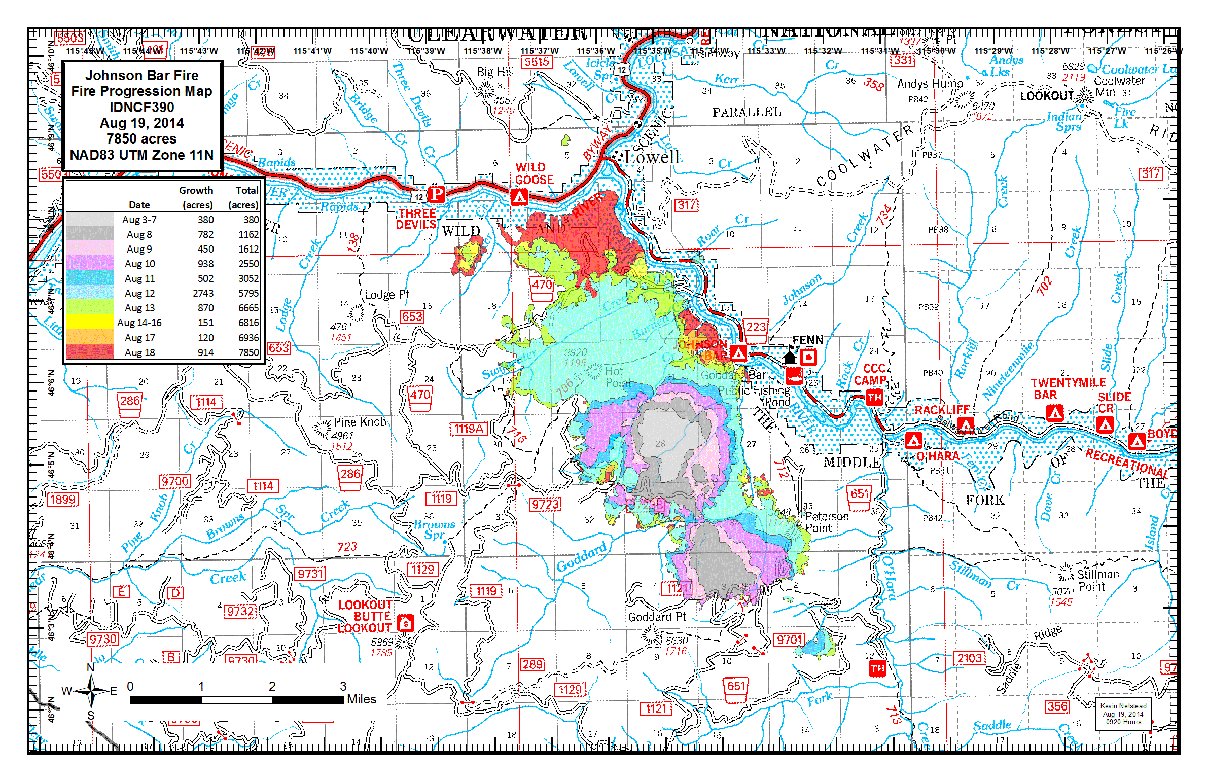
progression_11x17_land_20140819_0920_JohnsonBar_0819day.gif
2023-11-16 12:23
374K
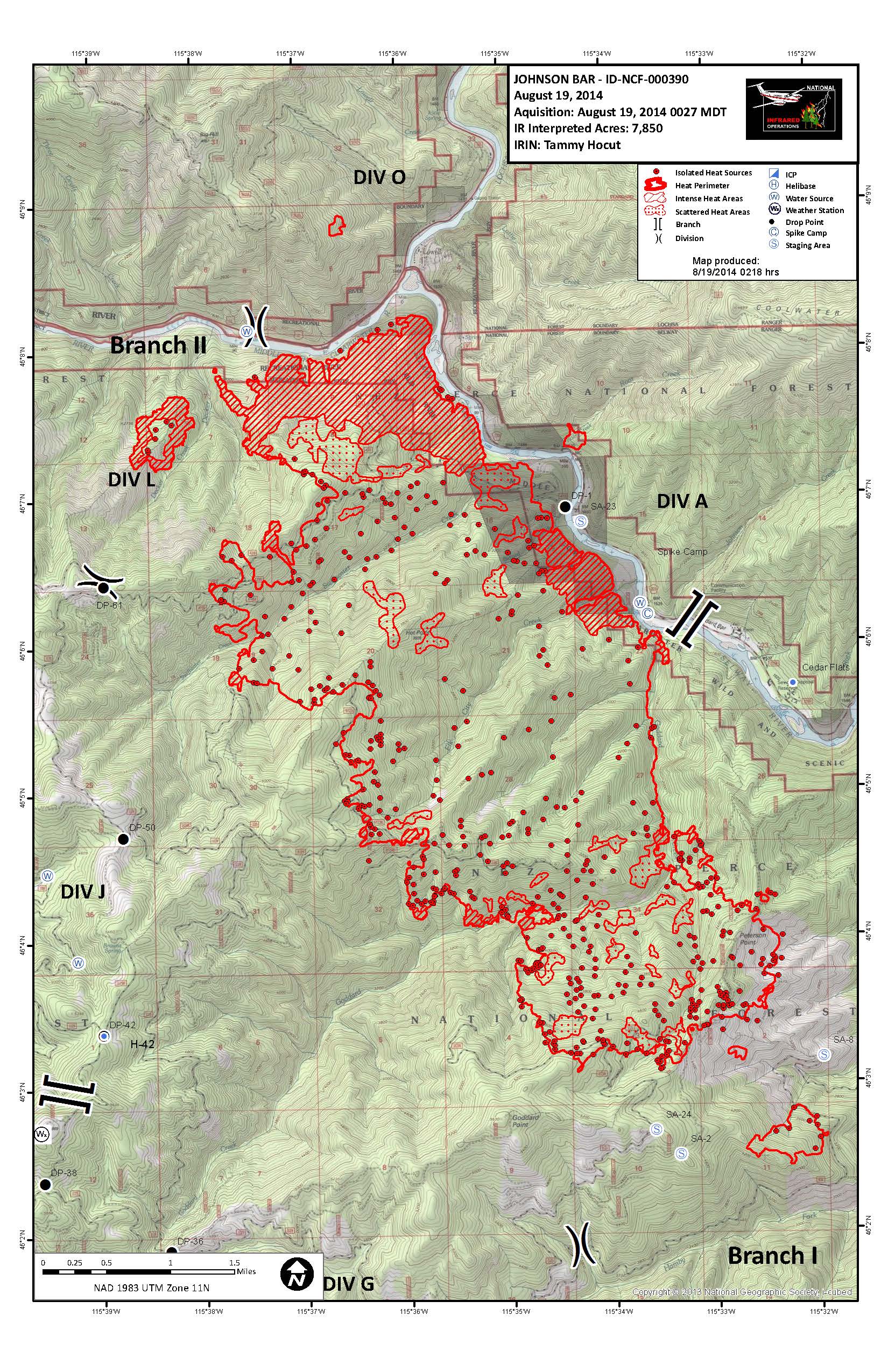
20140819_JohnsonBar_11x17.jpg
2023-11-16 12:20
708K
progression_11x17_land_20140819_0920_JohnsonBar_0819day.pdf
2023-11-16 12:23
1.4M
CrewMaps_11x17_land_DIVG_20140818_1920_JohnsonBar_0819day.pdf
2023-11-16 12:23
1.9M
CrewMaps_11x17_land_DIVA_20140818_1920_JohnsonBar_0819day.pdf
2023-11-16 12:23
2.0M
CrewMaps_11x17_land_DIVL_20140818_1920_JohnsonBar_0819day.pdf
2023-11-16 12:23
2.0M
AirOPS_11x17_land_pilot_20140819_0723_JohnsonBar_0819day.pdf
2023-11-16 12:20
2.0M
iap_multipage_8x11_land_20140818_2000_JohnsonBar_0819day.pdf
2023-11-16 12:23
2.1M
transp_11x17_land_20140819_1045_JohnsonBar_0819day.pdf
2023-11-16 12:23
2.2M
transp_11x17_land_20140818_1945_JohnsonBar_0819day.pdf
2023-11-16 12:23
2.3M
CrewMaps_11x17_land_DIVJ_20140818_1920_JohnsonBar_0819day.pdf
2023-11-16 12:23
2.3M
CrewMaps_11x17_land_DIVD_20140818_1920_JohnsonBar_0819day.pdf
2023-11-16 12:23
2.9M
20140819_JohnsonBar_11x17.pdf
2023-11-16 12:20
7.1M
brief_33x44_port_20140819_1340_JohnsonBar_0819day_reduced.pdf
2023-11-16 12:23
9.3M
Rehab_34x44_port_20140819_1150_JohnsonBar.pdf
2023-11-16 12:23
31M
brief_33x44_port_20140819_1340_JohnsonBar_0819day.pdf
2023-11-16 12:22
43M
brief_33x44_port_20140819_0707_JohnsonBar_0819day.pdf
2023-11-16 12:21
44M
20140819_JohnsonBar_33x44.pdf
2023-11-16 12:20
54M