Index of /public/incident_specific_data/n_rockies/Historic_archived NIROPS/2017_fires/2017_Liberty/GIS/Products/20170905
Name
Last modified
Size
Description
Parent Directory
-
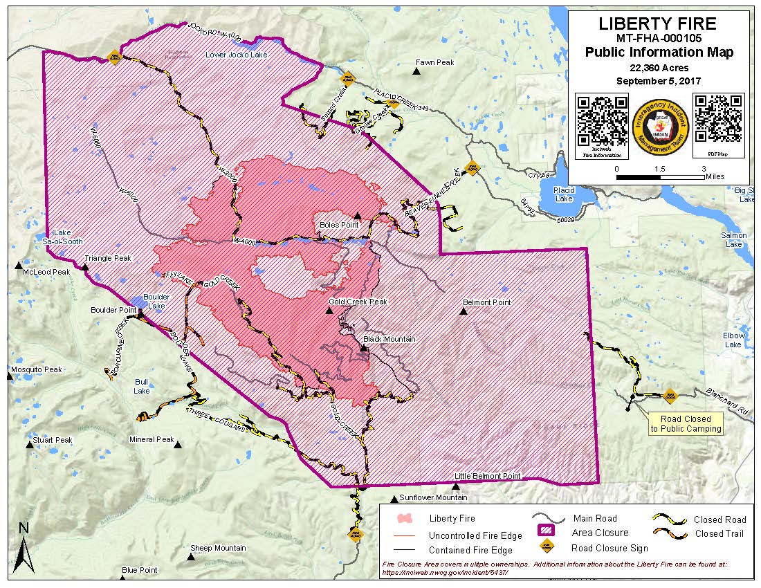
PIO_8x11_land_20170905_0845_Liberty_MTFHA105.jpg
2017-09-05 09:47
272K
PIO_8x11_land_20170905_0845_Liberty_MTFHA105.pdf
2017-09-05 09:47
388K
OPS_AnsiC_land_imagery_20170905_0531_Liberty_MTFHA105.pdf
2017-09-05 06:34
919K
TFR_ArchE_land_20170904_2145_Liberty_MTFHA105.pdf
2017-09-04 23:00
6.2M
Trans_85X11_land_20170904_1900_Liberty_MTFHA105.pdf
2017-09-04 22:59
208K
RepairDIVMTU_AnsiC_land_20170904_2020_Liberty_MTFHA105.pdf
2017-09-04 22:59
2.3M
RepairDIVC_AnsiC_land_20170904_2020_Liberty_MTFHA105.pdf
2017-09-04 22:58
2.3M
RepairDIVAB_AnsiC_land_20170904_2010_Liberty_MTFHA105.pdf
2017-09-04 22:58
2.4M
OPS_AnsiC_land_20170904_2045_Liberty_MTFHA105.pdf
2017-09-04 22:58
4.1M
OPS_ArchE_land_20170904_2050_Liberty_MTFHA105.pdf
2017-09-04 22:57
3.0M
DIVU_AnsiC_land_20170904_2023_Liberty_MTFHA105.pdf
2017-09-04 22:56
1.1M
IAP_85x11_land_20170904_1900_Liberty_MTFHA105.pdf
2017-09-04 22:56
514K
DIVT_AnsiC_land_20170904_2023_Liberty_MTFHA105.pdf
2017-09-04 22:56
1.3M
DIVM_AnsiC_land_20170904_2023_Liberty_MTFHA105.pdf
2017-09-04 22:56
1.3M
DIVC_AnsiC_land_20170904_2023_Liberty_MTFHA105.pdf
2017-09-04 22:56
1.2M
DIVAB_AnsiC_land_20170904_2023_Liberty_MTFHA105.pdf
2017-09-04 22:56
1.3M
BAM_ArchE_land_20170904_2140_Liberty_MTFHA105.pdf
2017-09-04 22:55
4.6M
Trans_ArchD_land_20170904_1930_Liberty_MTFHA105.pdf
2017-09-04 22:54
2.0M
AirOps_11x17_land_20170904_1900_Liberty_MTFHA105.pdf
2017-09-04 22:54
367K