Index of /public/incident_specific_data/alaska/2013/2013_Stuart_Creek_2/GIS/Products/20130724
Name
Last modified
Size
Description
Parent Directory
-
20130724_0510_AK_Ops_Div_KL_IR_ansi_C_port_2013_Stuart_Creek_2_AKMID280.pdf
2013-07-24 11:29
8.9M
20130724_0510_AK_Ops_Div_M_IR_ansi_C_port_2013_Stuart_Creek_2_AKMID280.pdf
2013-07-24 11:29
7.5M
20130724_0510_AK_Ops_Div_NP_IR_ansi_C_port_2013_Stuart_Creek_2_AKMID280.pdf
2013-07-24 11:29
11M
20130724_0510_AK_Ops_Div_R_IR_ansi_C_port_2013_Stuart_Creek_2_AKMID280.pdf
2013-07-24 11:29
11M
20130724_0510_AK_Ops_Div_S_IR_ansi_C_port_2013_Stuart_Creek_2_AKMID280.pdf
2013-07-24 11:30
11M
20130724_0535_AK_IR_ansi_e_port_2013_Stuart_Creek_2_AKMID280.pdf
2013-07-24 11:30
23M
20130724_AK_AirOps_AKMID_Stuart_Creek_2_11x17_port_day_binder.pdf
2013-07-24 01:21
6.1M
20130724_AK_IAP_AKMID_Stuart_Creek_2_iap_11x17_day.pdf
2013-07-24 01:21
5.8M
20130724_AK_ops_ansi_e_port_2013_Stuart_Creek_2_AKMID280.pdf
2013-07-24 01:22
32M
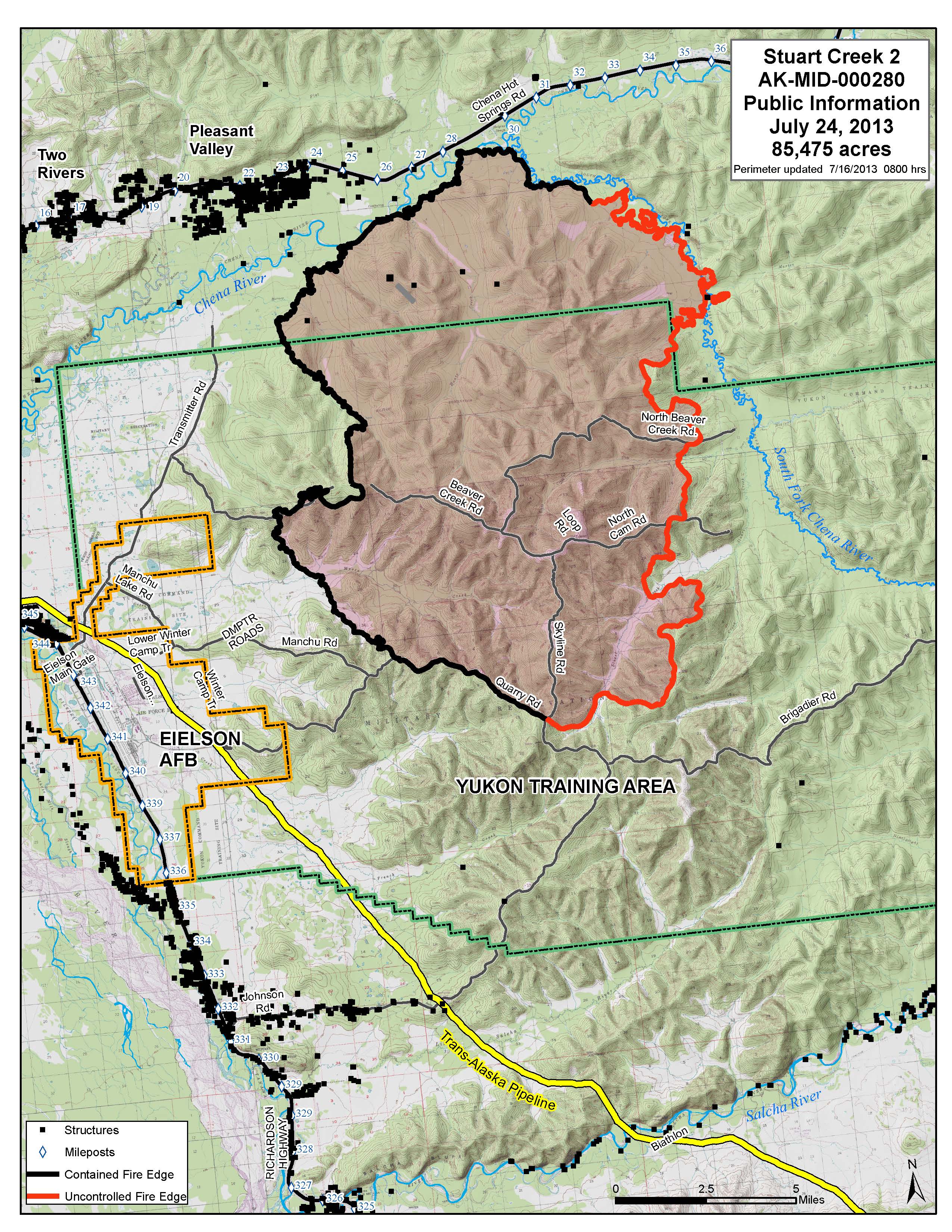
20130724_AK_pio_8x11_port_Stuart_Creek_2_AKMID280.jpg
2013-07-24 01:21
1.3M
20130724_AK_pio_8x11_port_Stuart_Creek_2_AKMID280.pdf
2013-07-24 01:21
4.2M
20130724_AK_trans_StuartCreek_8x11_port_day.pdf
2013-07-24 01:21
504K
20130724_StuartCreek2_KMZ.kmz
2013-07-24 01:21
177K
20130724_StuartCreek2_with_labels_KMZ.kmz
2013-07-24 01:21
177K