Index of /public/incident_specific_data/n_rockies/Historic_archived NIROPS/2017_fires/2017_Liberty/GIS/Products/20170902
Name
Last modified
Size
Description
Parent Directory
-
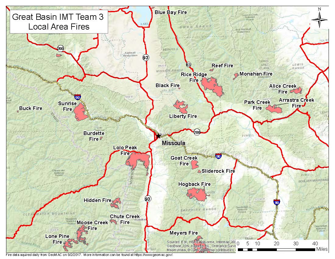
PIO_AreaFires_8x11_land_20170902_0815_Liberty_MTFHA105.jpg
2017-09-02 09:12
179K
Trans_85X11_land_20170901_1750_Liberty_MTFHA105.pdf
2017-09-01 23:19
205K
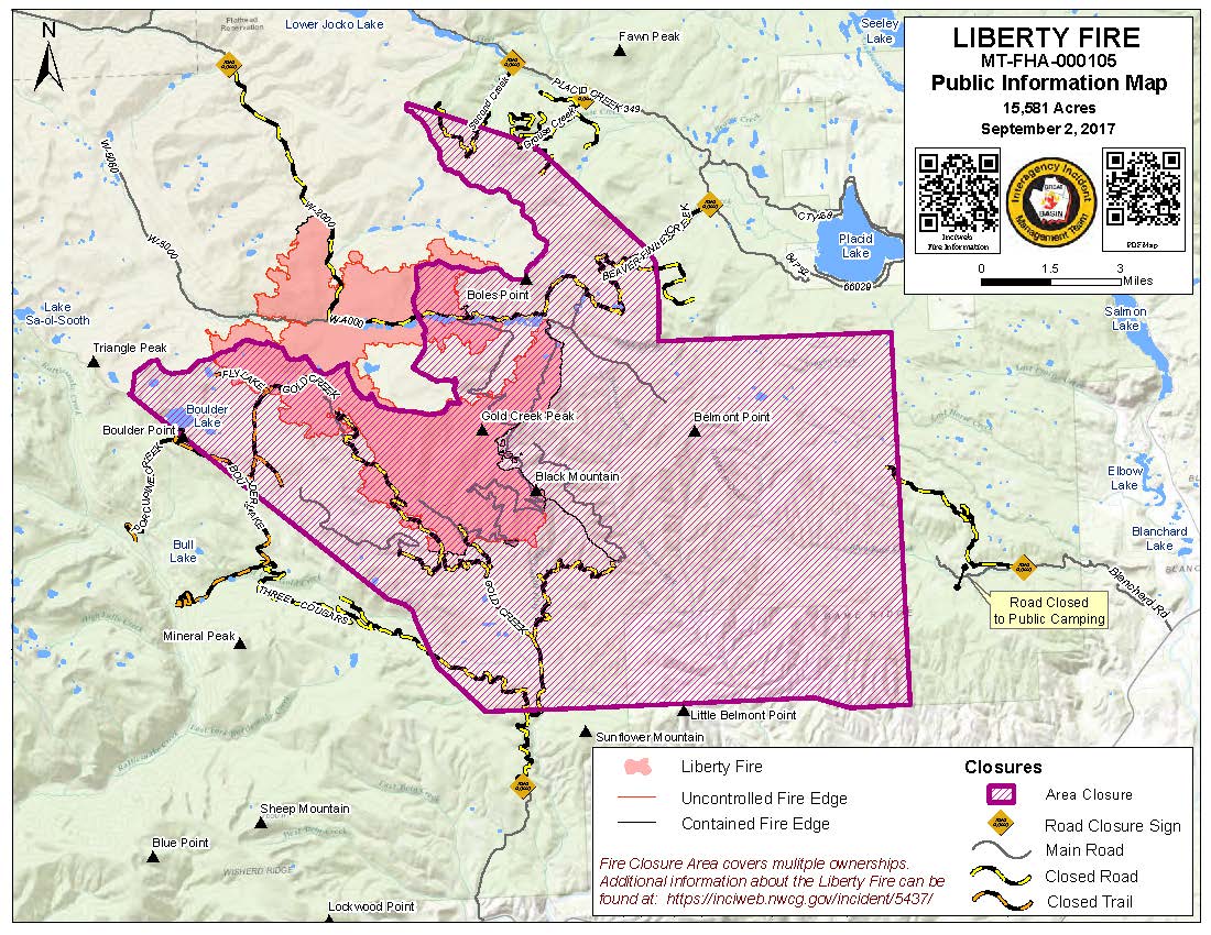
PIO_8x11_land_20170902_0643_Liberty_MTFHA105.jpg
2017-09-02 07:56
236K
PIO_AreaFires_8x11_land_20170902_0815_Liberty_MTFHA105.pdf
2017-09-02 09:12
363K
AirOps_11x17_land_20170901_2130_Liberty_MTFHA105.pdf
2017-09-01 23:19
367K
PIO_8x11_land_20170902_0643_Liberty_MTFHA105.pdf
2017-09-02 07:56
385K
IAP_85x11_land_20170901_1750_Liberty_MTFHA105.pdf
2017-09-01 23:21
514K
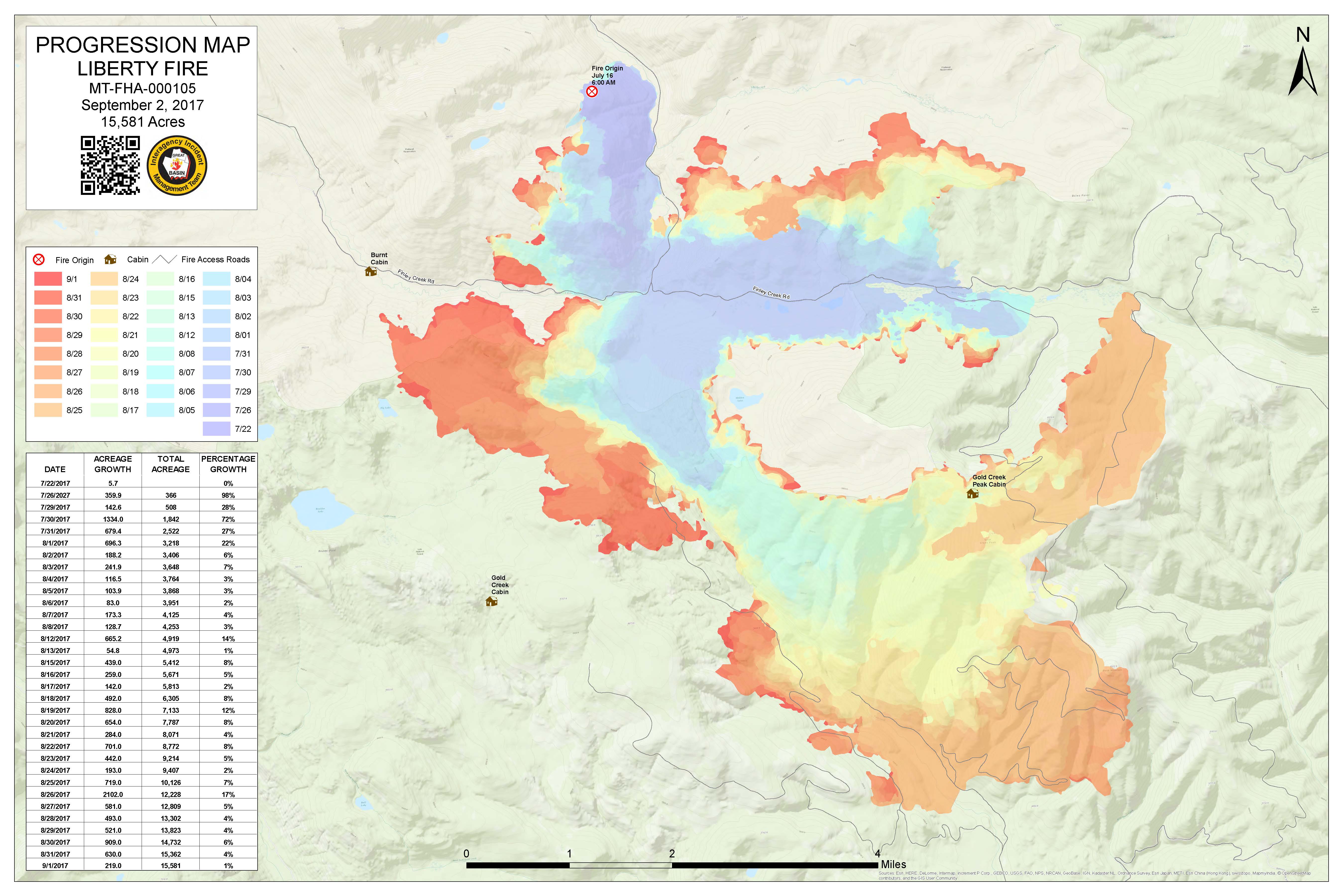
Progression_archD_land_20170902_0650_Liberty_MTFHA105.jpg
2017-09-02 07:56
1.0M
Progression_archD_land_20170902_0650_Liberty_MTFHA105.pdf
2017-09-02 07:56
1.2M
BAM_ArchE_land_2017091_2128_Liberty_MTFHA105.pdf
2017-09-01 23:20
1.9M
DIVU_AnsiC_land_20170901_2120_Liberty_MTFHA105.pdf
2017-09-01 23:21
2.0M
DIVC_AnsiC_land_20170901_2120_Liberty_MTFHA105.pdf
2017-09-01 23:20
2.1M
DIVT_AnsiC_land_20170901_2120_Liberty_MTFHA105.pdf
2017-09-01 23:20
2.2M
DIVM_AnsiC_land_20170901_2120_Liberty_MTFHA105.pdf
2017-09-01 23:20
2.3M
RepairDIVC_AnsiC_land_20170901_2120_Liberty_MTFHA105.pdf
2017-09-01 23:23
2.3M
RepairDIVAB_AnsiC_land_20170901_2021_Liberty_MTFHA105.pdf
2017-09-01 23:23
2.4M
TFR_ArchE_land_20170901_2140_Liberty_MTFHA105.pdf
2017-09-01 23:24
2.5M
OPS_ArchE_land_20170901_2130_Liberty_MTFHA105.pdf
2017-09-01 23:22
3.0M
OPS_AnsiC_land_20170901_2130_Liberty_MTFHA105.pdf
2017-09-01 23:22
3.6M
Repair_ArchE_land_20170901_2135_Liberty_MTFHA105.pdf
2017-09-01 23:23
4.6M
RepairDIVMTU_AnsiC_land_20170901_2120_Liberty_MTFHA105.pdf
2017-09-01 23:24
5.7M