Index of /public/incident_specific_data/rocky_mtn/2013/West_Fork_Complex/Products/20130702
Name
Last modified
Size
Description
Parent Directory
-
Div_ansiD_port_20130702_0600_West_Fork_Complex_SFJ000285.pdf
2013-07-02 00:11
117M
AirOps_ansiE_land_20130702_0600_WestFork_CO-SJF-000285.pdf
2013-07-02 00:09
33M
Sit_ansiE_land_20130702_0600_WestFork_CO-SJF-000285.pdf
2013-07-02 00:11
30M
IAP_11x17_port_MP_20130702_0600_WestFork_CO-SJF-000285.pdf
2013-07-02 00:10
28M
Tactical_WestFork_ansi_d_land_20130702_0600_West_Fork_Complex_SFJ000285.pdf
2013-07-02 00:11
14M
20130702_0515_WestFork_Briefing0702day_80k_36x48_Land.pdf
2013-07-02 10:28
14M
20130702_0630_WestFork_IAP_WestZone_11x17_Port1.pdf
2013-07-02 00:04
12M
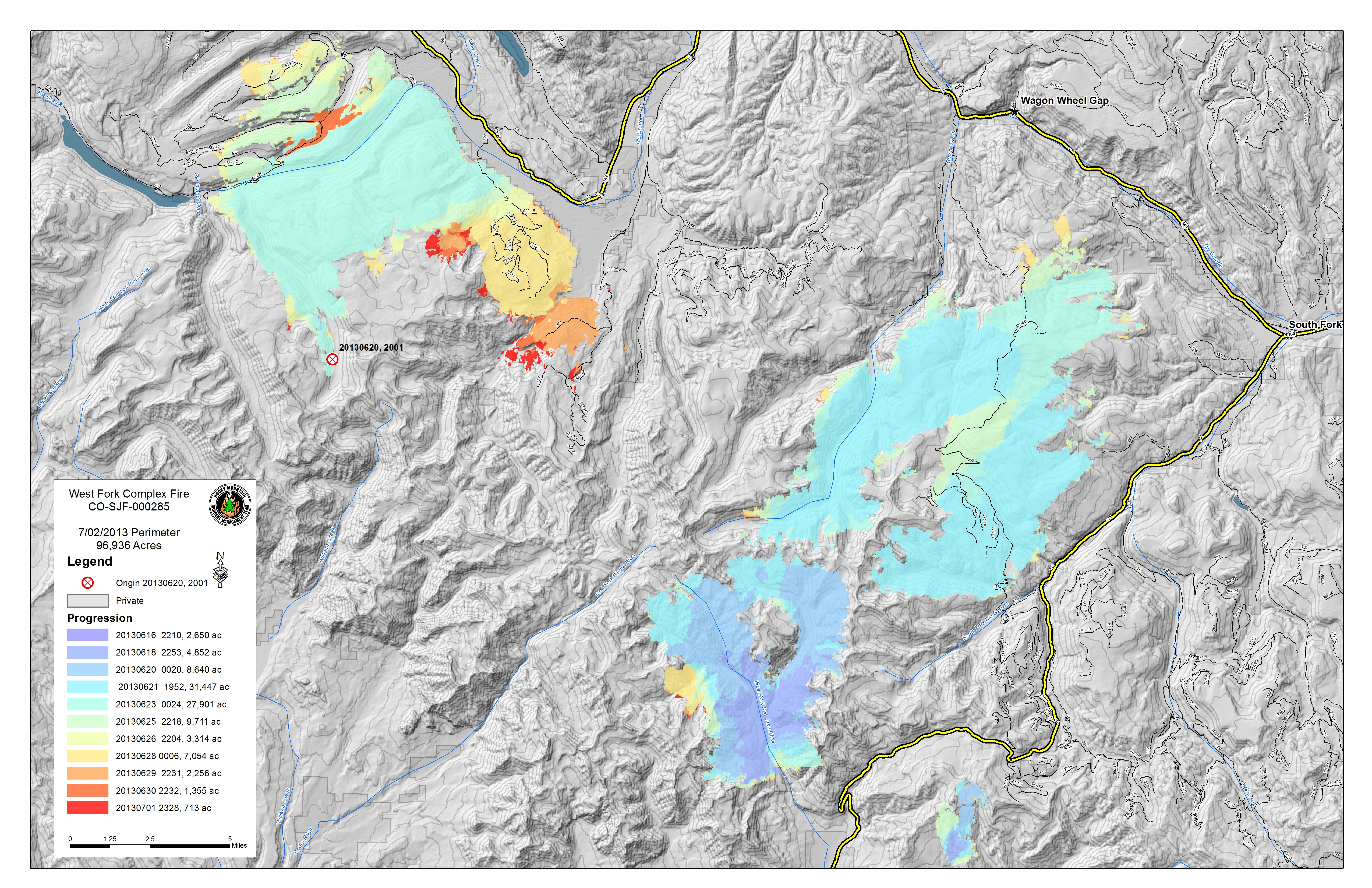
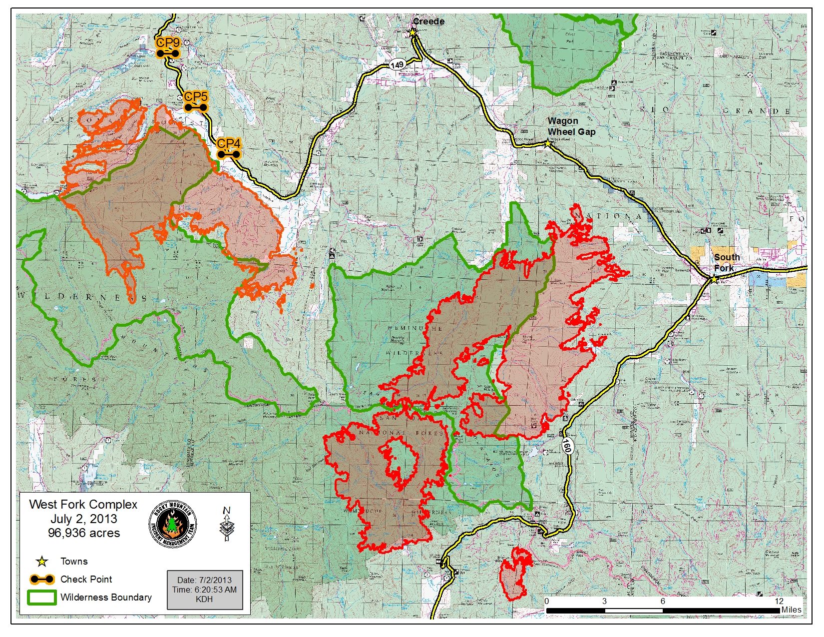
Progression_ansiD_land_2013_WestFork_CO-SJF-000285.jpg
2013-07-02 12:28
10M
20130702_Papoose_IR_Map_11X17.pdf
2013-07-02 10:29
6.9M
20130702_0900_WestFork_WestZone_PIO_11x17.pdf
2013-07-02 10:28
6.2M
20130702_West_Fork_Windy_Pass_IR_Map.pdf
2013-07-02 10:29
4.7M
Progression_ansiD_land_2013_WestFork_CO-SJF-000285.pdf
2013-07-02 12:28
4.3M
20130702_Windy_Pass_IR_Map.pdf
2013-07-02 10:30
4.2M
WestFork_Air_Attack_11x17_land_TOPO.pdf
2013-07-01 23:35
3.8M
20130702_0900_WestFork_WestZone_PIO_11x17.jpg
2013-07-02 10:27
2.7M
PIO_8x11_land_WestForkComplex_CO_SJF285.jpg
2013-07-02 08:23
2.7M
Transportation_11x17_land_20130702_0600_WestFork_CO-SJF-000285.pdf
2013-07-02 00:11
1.7M
PIO_8x11_land_WestForkComplex_CO_SJF285.pdf
2013-07-02 08:23
1.7M
Tactical_Papoose_ansiC_land_20130702_0600_West_Fork_Complex_SFJ000285.pdf
2013-07-02 00:11
1.4M
WestFork_Air_Attack_11x17_land.pdf
2013-07-01 23:34
1.3M
20130702_0630_WestFork_IAP_WestZone_Index_11x17_Port.pdf
2013-07-02 00:03
718K
WestFork_Pilot_Legend_11x17.pdf
2013-07-01 22:26
102K