Index of /public/incident_specific_data/rocky_mtn/2013/West_Fork_Complex/Products/20130701
Name
Last modified
Size
Description
Parent Directory
-
WestFork_Air_Attack_11x17_land_TOPO.pdf
2013-06-30 23:52
3.7M
WestFork_Pilot_Legend_11x17.pdf
2013-06-30 23:52
101K
WestFork_Air_Attack_11x17_land.pdf
2013-06-30 23:53
1.4M
WestFork_IAP_WestZone_11x17_Port.pdf
2013-07-01 00:13
12M
WestFork_IAP_WestZone_Index_11x17_Port.pdf
2013-07-01 00:19
698K
DIV_ansiC_land_20130701_0600_WestFork_CO-SJF-000285_Div W.pdf
2013-07-01 01:18
5.7M
DIV_ansiC_land_20130701_0600_WestFork_CO-SJF-000285_Div X.pdf
2013-07-01 01:18
5.5M
AirOps_ansiE_land_20130701_0600_WestFork_CO-SJF-000285.pdf
2013-07-01 01:19
33M
Briefing_Papoose_ansiE_land_20130701_0600_West_Fork_Complex_SFJ000285.pdf
2013-07-01 01:20
27M
DIV_ansiC_land_20130701_0600_WestFork_CO-SJF-000285_Div G.pdf
2013-07-01 01:20
5.6M
DIV_ansiC_land_20130701_0600_WestFork_CO-SJF-000285_Div J.pdf
2013-07-01 01:20
5.3M
DIV_ansiC_land_20130701_0600_WestFork_CO-SJF-000285_Div K.pdf
2013-07-01 01:20
5.3M
DIV_ansiC_land_20130701_0600_WestFork_CO-SJF-000285_Div M_ Div N.pdf
2013-07-01 01:20
5.6M
DIV_ansiC_land_20130701_0600_WestFork_CO-SJF-000285_Div O.pdf
2013-07-01 01:21
6.4M
DIV_ansiC_land_20130701_0600_WestFork_CO-SJF-000285_Div P.pdf
2013-07-01 01:21
6.0M
DIV_ansiC_land_20130701_0600_WestFork_CO-SJF-000285_Div T.pdf
2013-07-01 01:21
5.7M
DIV_ansiC_land_20130701_0600_WestFork_CO-SJF-000285_Div U.pdf
2013-07-01 01:21
5.6M
Sit_ansiE_land_20130701_0600_WestFork_CO-SJF-000285.pdf
2013-07-01 01:24
30M
Tactical_Papoose_ansiC_land_20130701_0600_West_Fork_Complex_SFJ000285.pdf
2013-07-01 01:24
5.6M
Tactical_WestFork_ansi_d_land_20130701_0600_West_Fork_Complex_SFJ000285.pdf
2013-07-01 01:24
14M
Transportation_11x17_land_20130701_WestFork_CO-SJF-000285.pdf
2013-07-01 01:24
1.2M
IAP_11x17_port_20130701_0600_WestFork_CO-SJF-000285.pdf
2013-07-01 01:25
30M
IAP_11x17_port_MP_20130701_0600_WestFork_CO-SJF-000285.pdf
2013-07-01 01:26
30M
IAP_Index_11x17_port_20130701_0600_WestFork_CO-SJF-000285.pdf
2013-07-01 01:26
570K
MGRS_NatGuard_20130701_0600_WestFork_CO-SJF-000285.pdf
2013-07-01 01:27
30M
Rehab_ansiE_land_2013_West_Fork_CO-SJF-000285.pdf
2013-07-01 01:29
64M
Rehab_Overview_ansiE_land_2013_West_Fork_CO-SJF-000285.pdf
2013-07-01 01:31
78M
20130701_0600_WestFork_Briefing_0701day_80k_36x48_Land.pdf
2013-07-01 08:31
14M
20130701_0530_WestFork_Ops_0701day_24k_36x48_Land.pdf
2013-07-01 08:40
16M
PIO_8x11_land_WestForkComplex_CO_SJF285.pdf
2013-07-01 08:50
1.7M
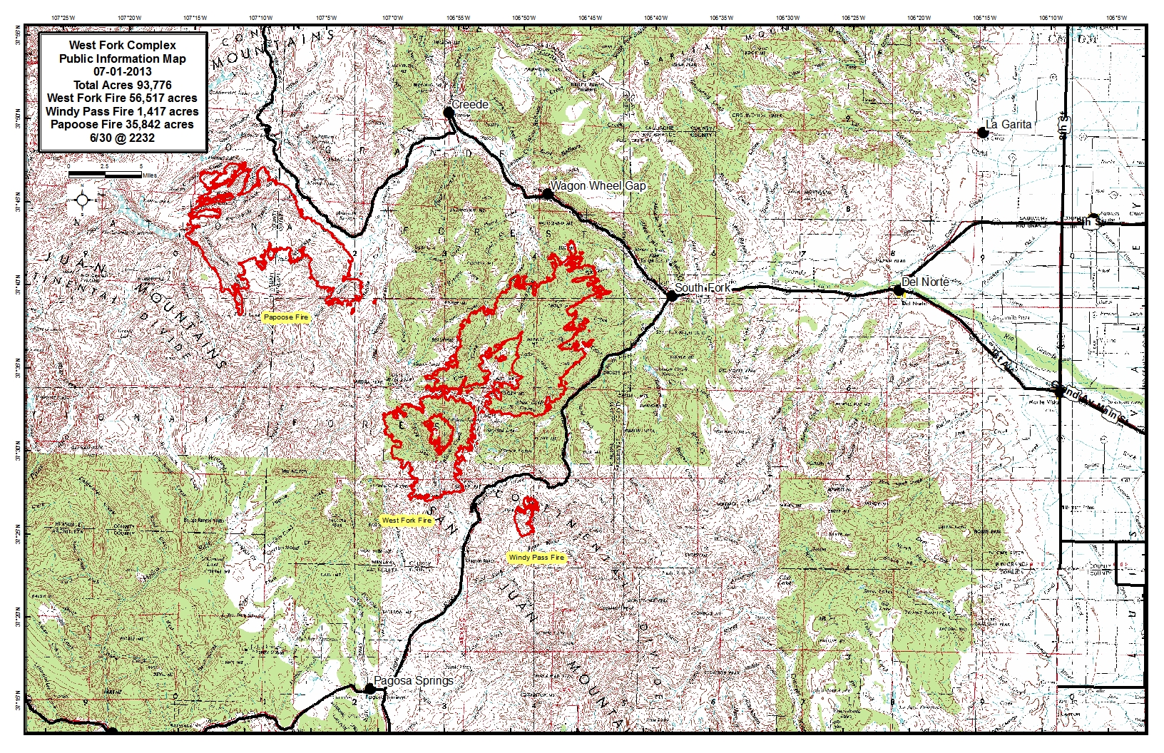
20130701_WestFork_WestZone_PIO_11x17.jpg
2013-07-01 09:35
2.7M
20130701_WestFork_WestZone_PIO_11x17.pdf
2013-07-01 09:36
6.2M