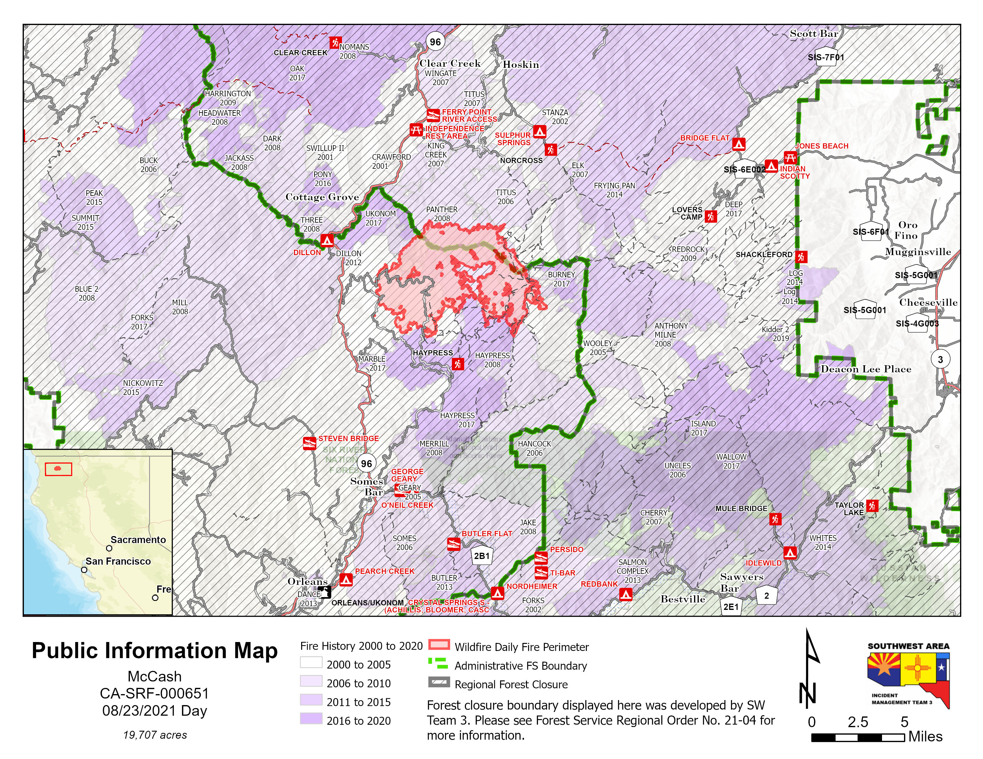
Index of /public/incident_specific_data/calif_n/2021_FEDERAL_Incidents/CA-SRF-651_McCash/GIS/Products/20210823
Name
Last modified
Size
Description
Parent Directory
-
structures_TiBarRoad_c_port_20210822_2018_McCash_CASRF000651_0823day_geo.pdf
2021-08-22 23:00
6.1M
structures_RodgersCreek_c_port_20210822_2004_McCash_CASRF000651_0823day_geo.pdf
2021-08-22 23:00
5.0M
structures_PattersonMarbleMtn_c_port_20210822_2046_McCash_CASRF000651_0823day_geo.pdf
2021-08-22 23:06
6.4M
structures_CottageGrove_c_port_20210822_2004_McCash_CASRF000651_0823day_geo.pdf
2021-08-22 23:00
6.5M
report_structures_TiBarRoad_20210822_2115_McCash_CASRF000651_0823day.pdf
2021-08-22 23:34
3.9M
report_structures_RodgersCreek_20210822_21135_McCash_CASRF000651_0823day.pdf
2021-08-22 23:34
2.0M
report_structures_Patterson_20210822_2120_McCash_CASRF000651_0823day.pdf
2021-08-22 23:34
5.1M
report_structures_MarbleMtnRanch_20210822_2045_McCash_CASRF000651_0823day.pdf
2021-08-22 23:13
4.7M
report_structures_CottageGrove_20210822_2042_McCash_CASRF000651_0823day.pdf
2021-08-22 23:12
1.1M
progression_arch_e_land_20210823_0828_McCash_CASRF000651_0823day.pdf
2021-08-23 11:58
4.5M
pio_letter_land_20210823_00825_McCash_CASRF000651_0823day.jpg
2021-08-23 11:56
2.0M
pio__letter_land_20210823_0816_McCash_CASRF000651_0823day.pdf
2021-08-23 11:56
3.3M
pilot_table_only_11x17_port_20210823_2047_McCash_CASRF000651_0823day.pdf
2021-08-23 11:54
646K
pilot_map_only_11x17_port_20210823_0849_McCash_CASRF000651_0823day_geo.pdf
2021-08-23 11:55
6.6M
ops_structures_topo_arch_e_port_20210823_1959_McCash_CASRF000651_0824_geo.pdf
2021-08-25 00:15
9.0M
ops_structures_topo_arch_e_port_20210822_1952_McCash_CASRF000651_0823day_geo.pdf
2021-08-22 23:01
9.9M
ops_arch_e_port_20210823_1617_McCash_CASRF000651_0823day_night.pdf
2021-08-23 18:25
21M
ops_arch_e_port_20210823_1604_McCash_CASRF000651_0823day_night.pdf
2021-08-25 00:17
0
ops_arch_e_port_20210823_0339_McCash_CASRF000651_0823day_geo.pdf
2021-08-23 05:47
20M
med_ground_arch_E_port_20210823_1913_McCash_CASRF000651_0824day_geo.pdf
2021-08-25 00:15
4.6M
med_ground_arch_E_port_20210822_2000_McCash_CASRF000651_0823day_geo.pdf
2021-08-22 23:01
4.6M
medEvac_arch_e_land_20210823_2018_McCash_CASRF000651_0824day.pdf
2021-08-25 00:17
0
ir_planning_ops_arch_e_port_20210823_1655_McCash_CASRF000651_0823day_geo.pdf
2021-08-25 00:16
0
ir_planning_ops_arch_e_port_20210823_0840_McCash_CASRF000651_0823day_geo.pdf
2021-08-25 00:17
0
fireHistory_arch_d_port_20210823_1737_McCash_CASRF000651_0824day.pdf
2021-08-25 00:17
0
evac_arch_e_port_20210823_1915_McCash_CASRF000651_0824day_geo.pdf
2021-08-25 00:15
4.3M
evac_arch_e_port_20210823_1751_McCash_CASRF000651_0824day_geo.pdf
2021-08-25 00:17
0
evac_arch_e_port_20210823_1503_McCash_CASRF000651_0823day_geo.pdf
2021-08-25 00:17
0
completed_burnout_letter_land_20210823_1653_McCash_CASRF000651_0823day.pdf
2021-08-23 18:57
4.1M
brief_arch_e_port_20210822_0355_McCash_CASRF000651_0823day_geo.pdf
2021-08-23 06:02
9.0M
air_ops_arch_e_port_20210823_1853_McCash_CASRF000651_0824day_geo.pdf
2021-08-25 00:16
15M
air_ops_arch_e_port_20210823_0832_McCash_CASRF000651_0823day_geo.pdf
2021-08-23 11:50
15M
account_prop_arch_E_port_20210823_2040_McCash_CASRF000651_0824day.pdf
2021-08-25 00:15
4.8M
FSPro14day_c_port_20210822_2127_McCash_CASRF000651_0823_geo.pdf
2021-08-25 00:17
0
AccountProp_arch_E_port_20210822_0631_McCash_CASRF000651_0823day.pdf
2021-08-22 23:06
4.7M