Index of /public/incident_specific_data/pacific_nw/Z_2017_HISTORIC/2017_Incidents_Oregon/2017_Jones_OR_WIF_170191/GIS/Products/20170907
Name
Last modified
Size
Description
Parent Directory
-
Ops Map Slot in Div G.pdf
2017-09-08 00:16
2.8M
repeaters_24x36_port_20170907_0600_Jones_ORWIF170191_Staley.pdf
2017-09-07 23:21
24M
vicinity_24x36_port_20170907_0600_Jones_ORWIF170191.pdf
2017-09-07 23:21
13M
repeaters_24x36_port_20170907_0600_Jones_ORWIF170191_Overview.pdf
2017-09-07 23:20
28M
repeaters_24x36_port_20170907_0600_Jones_ORWIF170191_Jones.pdf
2017-09-07 23:19
16M
progression_18x24_land_20170907_1000_Jones_ORWIF170191.pdf
2017-09-07 23:17
10M
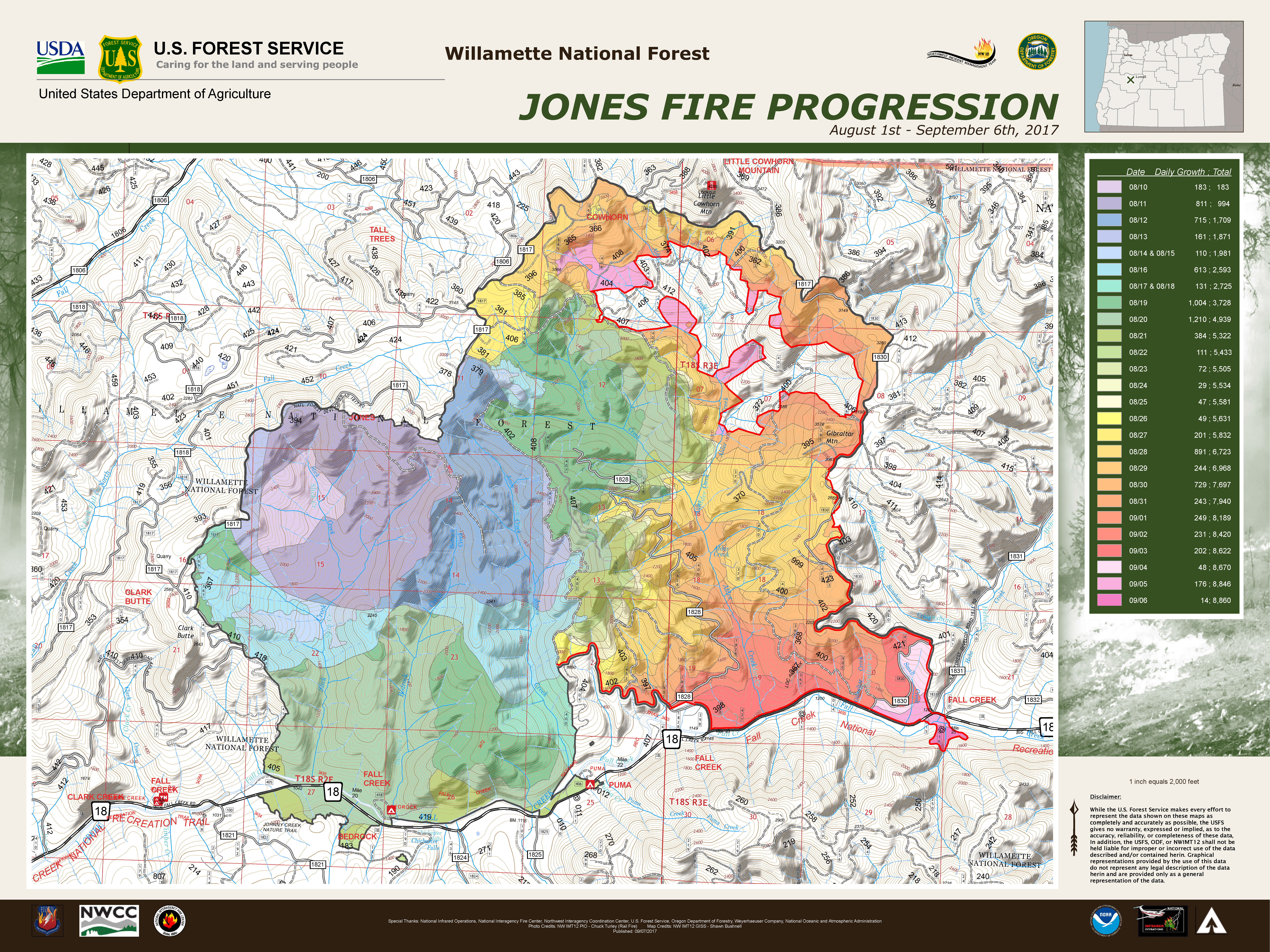
progression_18x24_land_20170907_1000_Jones_ORWIF170191.jpg
2017-09-07 23:17
11M
pio_8x11_port_20170907_0600_Jones_ORWIF170191.pdf
2017-09-07 23:16
1.3M
pio_18x24_port_20170907_0600_Jones_ORWIF170191.pdf
2017-09-07 23:16
2.2M
newstart_24x36_port_20170907_1200_Jones_ORWIF170191_Staley.pdf
2017-09-07 23:16
24M
pio_18x24_port_20170907_0600_Jones_ORWIF170191.jpg
2017-09-07 23:16
2.4M
pace_36x48_land_20170907_0800_Jones_ORWIF170191.pdf
2017-09-07 23:15
23M
Public Information Map Large 20170907.pdf
2017-09-07 13:33
2.2M
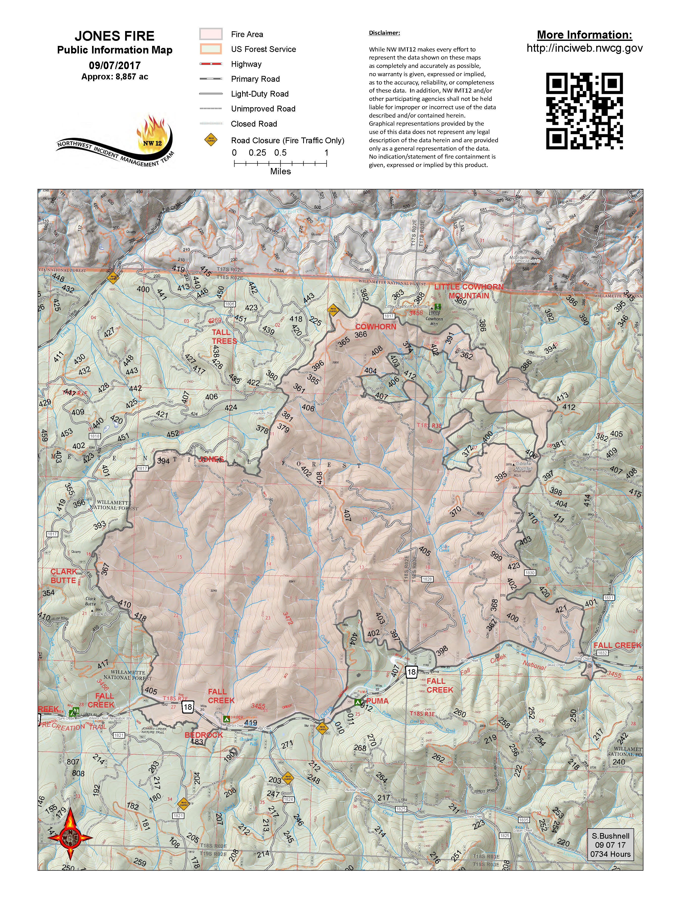
Public Information Map 20170907.pdf
2017-09-07 13:33
1.3M
tfr_36x48_port_20170907_0600_Jones_ORWIF170191.pdf
2017-09-07 01:26
11M
trans_8x11_land_20170907_0600_Jones_ORWIF170191.pdf
2017-09-07 01:25
506K
pilot_11x17_land_20170907_0600_Jones_ORWIF170191.pdf
2017-09-07 01:25
5.4M
ops_divs_18x24_land_20170907_0600_Jones_ORWIF170191_DIV Z.pdf
2017-09-07 01:25
8.2M
ops_divs_18x24_land_20170907_0600_Jones_ORWIF170191_DIV O.pdf
2017-09-07 01:24
8.5M
ops_divs_18x24_land_20170907_0600_Jones_ORWIF170191_DIV K.pdf
2017-09-07 01:24
7.1M
ops_divs_18x24_land_20170907_0600_Jones_ORWIF170191_DIV G.pdf
2017-09-07 01:23
8.8M
ops_divs_18x24_land_20170907_0600_Jones_ORWIF170191_DIV D.pdf
2017-09-07 01:23
9.8M
ops_divs_18x24_land_20170907_0600_Jones_ORWIF170191_DIV A.pdf
2017-09-07 01:22
8.9M
ops_18x24_land_20170907_0600_Jones_ORWIF170191_Fire Area.pdf
2017-09-07 01:21
17M
ops_18x24_land_20170907_0600_Jones_ORWIF170191_Contingency.pdf
2017-09-07 01:21
13M
brief_36x48_land_20170907_0600_Jones_ORWIF170191.pdf
2017-09-07 01:19
15M
ops_18x24_land_20170907_0600_Jones_ORWIF170191_Contingency North.pdf
2017-09-07 01:19
13M
iap_8x11_land_20170907_0600_Jones_ORWIF170191.pdf
2017-09-07 01:17
1.4M
TFR Map 20170907.pdf
2017-09-07 00:59
4.9M
Pilot Map 20170907.pdf
2017-09-07 00:59
812K
Ops Map Fire Area 20170907.pdf
2017-09-07 00:58
2.8M
Ops Map DIV O 20170907.pdf
2017-09-07 00:58
2.1M
Ops Map DIV Z 20170907.pdf
2017-09-07 00:58
2.1M
Ops Map DIV G 20170907.pdf
2017-09-07 00:58
2.2M
Ops Map DIV K 20170907.pdf
2017-09-07 00:58
1.9M
Ops Map DIV A 20170907.pdf
2017-09-07 00:57
2.3M
Ops Map DIV D 20170907.pdf
2017-09-07 00:57
2.3M
Ops Map Contingency North 20170907.pdf
2017-09-07 00:57
2.5M
Ops Map Contingency 20170907.pdf
2017-09-07 00:57
2.5M