Index of /public/incident_specific_data/n_rockies/Historic_archived NIROPS/2015_fires/2015_Thompson/GIS/Products/20150817
Name
Last modified
Size
Description
Parent Directory
-
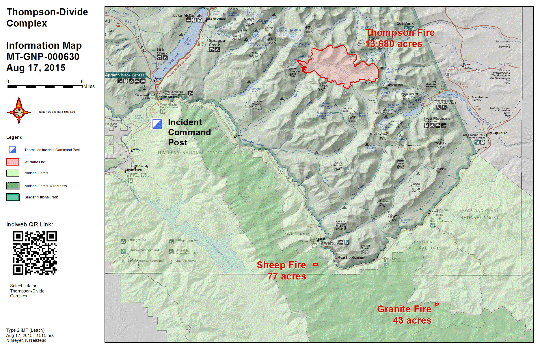
Information_11x17_land_20150817_1515_Thompson_MTGNP0000483_0817.gif
2015-08-17 23:55
788K
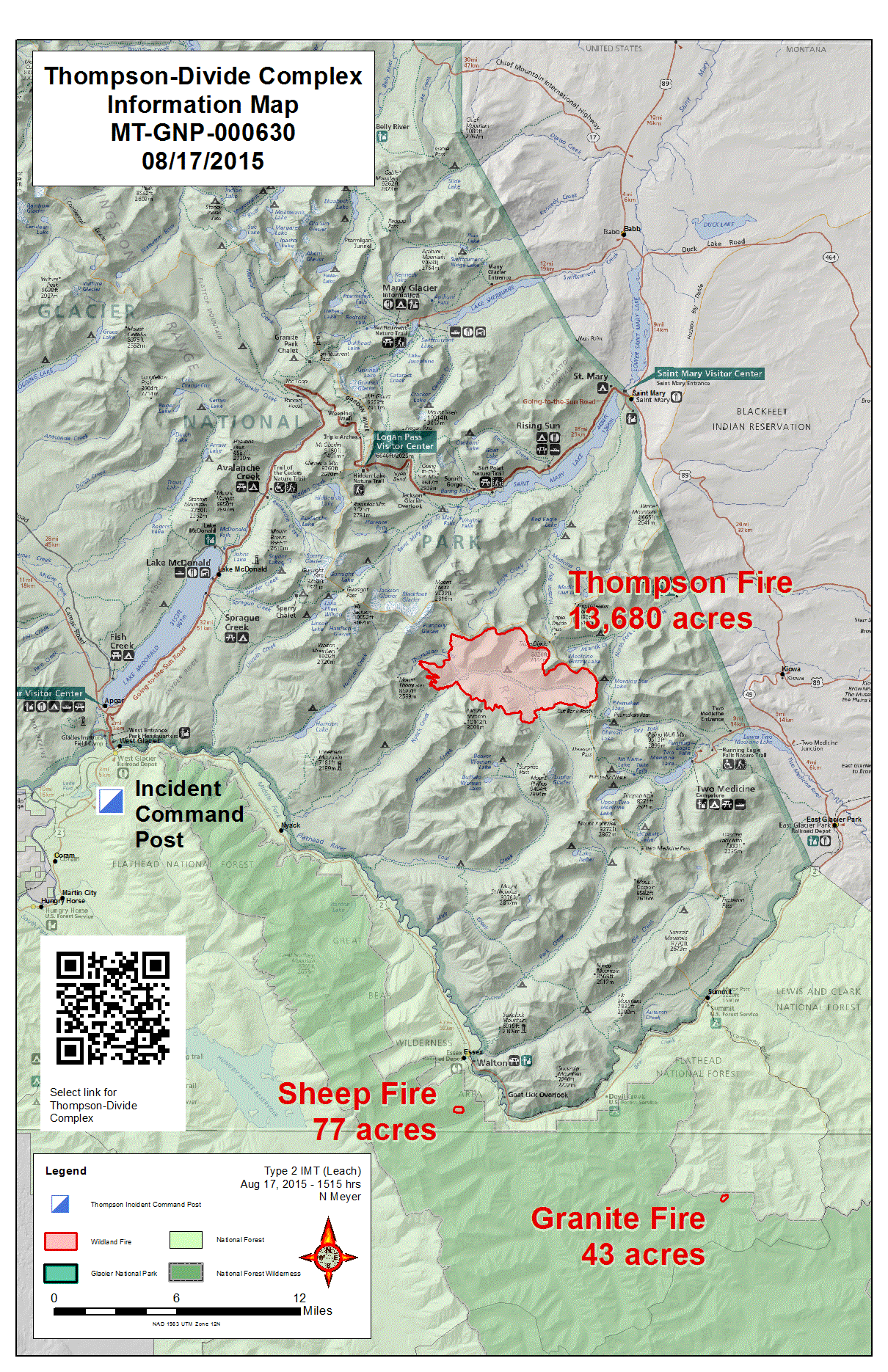
Information_11x17_port_20150817_1515_Thompson_MTGNP0000483_0817.gif
2015-08-17 23:55
838K
iap_8x11_land_20150816_1759_Thompson_MTGNP0000483_0817.pdf
2015-08-17 23:55
1.6M
Transportation_8x11_land_20150816_2100_Thompson_MTGNP0000483_0817.pdf
2015-08-17 23:56
2.1M
Transportation_8x11_land_20150816_1645_Thompson_MTGNP0000483_0817.pdf
2015-08-17 23:56
2.1M
Information_11x17_land_20150817_1515_Thompson_MTGNP0000483_0817.pdf
2015-08-17 23:56
2.6M
Information_11x17_port_20150817_1515_Thompson_MTGNP0000483_0817.pdf
2015-08-17 23:56
3.5M
TFR_8x11_port_20150817_1430_Thompson_MTGNP0000483_0817.pdf
2015-08-17 23:56
3.7M
TwoMedicineCG_11x17_land_20150817_0711_Thompson_MTGNP0000483_0817.pdf
2015-08-17 23:57
5.2M
crew_11x17_land_20150817_0944_Sheep_MTFNF000608_0817AM.pdf
2015-08-17 23:53
5.7M
crew_11x17_land_20150817_0815_Granite_MTFNF000625_0817AM.pdf
2015-08-17 23:52
5.7M
brief_AnsiE_land20150817_1741_Thompson_MTGNP0000483_0817PM.pdf
2015-08-17 23:50
6.9M
IAimagery_AnsiE_land_20150817_1000_ThompsonDivide_MTGNP0000483_0817.pdf
2015-08-17 23:54
9.0M
IAimagery_AnsiE_land_20150817_1650_ThompsonDivide_MTGNP0000483_0817.pdf
2015-08-17 23:54
9.1M
IAimagery_AnsiE_land_20150817_2135_ThompsonDivide_MTGNP0000483_0817.pdf
2015-08-17 23:55
9.2M
brief_AnsiE_land_20150816_2113_Thompson_MTGNP0000483_0817AM.pdf
2015-08-17 23:52
18M