Index of /public/incident_specific_data/n_rockies/Historic_archived NIROPS/2015_fires/2015_Thompson/GIS/Products/20150820
Name
Last modified
Size
Description
Parent Directory
-
IAimagery_AnsiE_land_20150820_1220_ThompsonDivide_MTGNP000630_0820.pdf
2015-08-21 00:19
9.6M
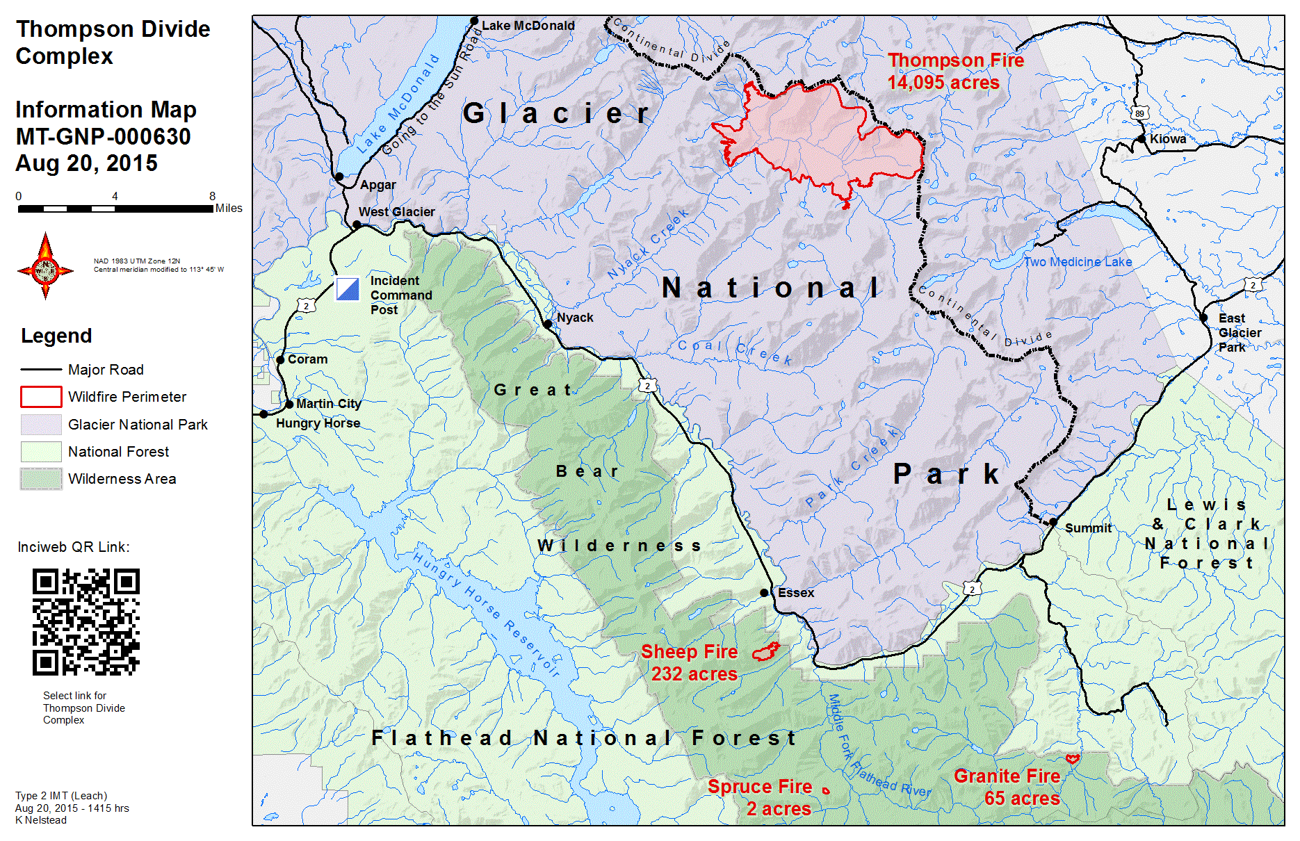
Information_11x17_land_20150820_1415_ThompsonDivide_MTGNP000630_0820.gif
2015-08-21 00:21
605K
Information_11x17_land_20150820_1415_ThompsonDivide_MTGNP000630_0820.pdf
2015-08-21 00:21
3.5M
PIO/
2015-08-21 00:22
-
Structure_8x11_land_pg1_20150820_1545_ThompsonDivide_MTGNP000630_0820PM.pdf
2015-08-21 00:21
397K
Structure_8x11_land_pg2_20150820_1545_ThompsonDivide_MTGNP000630_0820PM.pdf
2015-08-21 00:21
427K
Transportation_8x11_land_20150819_2020_ThompsonDivide_MTGNP000630_0820.pdf
2015-08-21 00:21
2.2M
VicinityBriefing_8x11_port_20150819_2145_ThompsonDivide_MTGNP000630_0820.pdf
2015-08-21 00:21
2.2M
VicinityBriefing_8x11_port_20150820_0855_ThompsonDivide_MTGNP000630_0820.pdf
2015-08-21 00:21
2.2M
brief_AnsiE_land20150820_0534_Thompson_MTGNP0000483_0820AM.pdf
2015-08-21 00:16
6.7M
brief_AnsiE_land_20150819_2142_Sheep_MTGNP000630_0820AM.pdf
2015-08-21 00:16
3.8M
brief_AnsiE_land_20150819_2157_Granite_MTGNP000630_0820AM.pdf
2015-08-21 00:16
3.3M
brief_AnsiE_land_20150819_2205_Thompson_MTGNP0000483_0820AM.pdf
2015-08-21 00:17
6.7M
brief_AnsiE_land_20150820_0528_Granite_MTGNP000630_0820AM.pdf
2015-08-21 00:17
5.8M
brief_AnsiE_land_20150820_0809_Sheep_MTGNP000630_0820AM.pdf
2015-08-21 00:18
5.4M
brief_AnsiE_land_20150820_1515_Sheep_MTGNP000630_8020PM.pdf
2015-08-21 00:20
35M
crew_11x17_land_20150820_0645_Sheep_MTFNF000608_0820.pdf
2015-08-21 00:18
5.6M
iap_8x11_land_pg1_20150819_2103_Thompson_MTGNP0000483_0820.pdf
2015-08-21 00:20
1.3M
iap_8x11_land_pg2_20150819_1908_ThompsonDivide_MTGNP000630_0820.pdf
2015-08-21 00:20
3.8M
iap_8x11_land_pg3_20150819_1908_ThompsonDivide_MTGNP000630_0820.pdf
2015-08-21 00:21
3.4M
iap_8x11_land_pg4_20150819_2038_ThompsonDivide_MTGNP000630_0820.pdf
2015-08-21 00:21
2.9M